
For Prelims: classification of volcanoes, global volcanic distribution, the Pacific Ring of Fire, the Circum-Pacific Belt, and subduction zones.
For Mains: Global distribution, importance, and impact of volcanic activities on the environment and human life.
Introduction
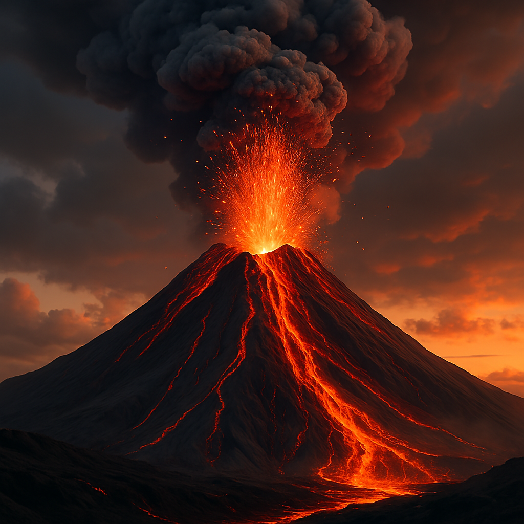
Volcanism is the endogenic process through which molten rock, gases, and other materials erupt from beneath a planet’s surface, forming various landforms. It is a crucial geological phenomenon that shapes landscapes, influences climate, and affects ecosystems. In this article, we will discuss the types, distribution, and impact of volcanism while incorporating scientific insights into its prediction and monitoring.
Understanding volcanism is essential for both Prelims and Mains, as it is a key topic in Geography, Disaster Management, and Environmental Science, frequently asked in UPSC and state PSC exams.
Understanding Volcanism
Volcanism, or you can say volcanic activity, occurs when internal heat melts portions of the Earth’s mantle, leading to the formation of magma. When this molten rock reaches the surface, it is called lava. The movement of magma results in both intrusive (beneath the surface) and extrusive (on the surface) landforms.
Magma vs. Lava :
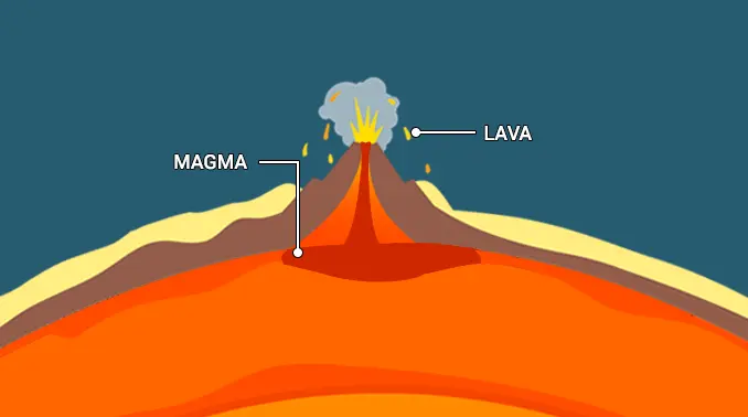
| Term | Definition |
| Magma | Molten rock stored beneath the Earth’s surface |
| Lava | Magma that has reached the surface and flows as liquid rock |
Types of Volcanoes Based on Eruption Frequency
- Active Volcanoes
- These volcanoes erupt frequently and are mostly found in the Pacific Ring of Fire, which includes regions like New Zealand, Southeast Asia, Japan, and the western coast of the Americas.
- This region experiences about 90% of the world’s earthquakes due to the movement and collision of tectonic plates.
- Examples of active volcanoes include Kilauea in Hawaii and Santa Maria in Guatemala.
- Dormant Volcanoes
- These volcanoes have not erupted in recent history but are not extinct and may become active in the future.
- An example is Mount Kilimanjaro in Tanzania, the highest mountain in Africa, which is classified as a dormant volcano.
- Extinct or Inactive Volcanoes
- These volcanoes have not erupted in the distant geological past and are unlikely to erupt again.
- An example is Dhinodhar Hill in Gujarat.
Types of Volcanoes Based on Structure and Eruption Style
- Shield Volcanoes
- These are the largest and most gently sloping volcanoes, primarily formed from basalt lava.
- They usually erupt with low explosivity unless water interacts with the vent.
- The lava flows in a fountain-like manner, forming a cinder cone around the vent before spreading out.
- Classic examples include the Hawaiian volcanoes.
- Composite Volcanoes
- Also known as stratovolcanoes, these volcanoes erupt cooler and thicker lava compared to shield volcanoes.
- They are built up over time through multiple explosive eruptions, layering ash, pyroclastic material, and lava flows.
- Many composite volcanoes are found in the Pacific Ring of Fire, including Mayon Volcano (Philippines), Mount Fuji (Japan), and Mount Rainier (Washington, USA).
- Calderas
- These are among the most explosive volcanoes, often collapsing inward during an eruption rather than building upwards.
- The resulting large depressions formed by these collapses are called calderas.
- Flood Basalt Provinces
- These volcanoes erupt highly fluid lava that spreads over vast distances, creating thick basalt layers across large areas.
- Mid-Ocean Ridge Volcanoes
- Found along the mid-ocean ridge system, which stretches over 65,000 kilometers across ocean basins, these underwater volcanoes erupt frequently along the central ridge.
- Found along the mid-ocean ridge system, which stretches over 65,000 kilometers across ocean basins, these underwater volcanoes erupt frequently along the central ridge.
Global Distribution of Volcanic Activity
Most volcanic activity occurs along converging plate boundaries and mid-oceanic ridges. The Circum-Pacific Belt, also known as the “Ring of Fire,” accounts for nearly 75% of the world’s active volcanoes. Another 20% are found in the Mediterranean-Himalayan Belt, which includes Asia Minor, the Himalayas, and parts of northwest China.
Since the 16th century, approximately 480 volcanoes have been recorded as active. Of these, nearly 400 are located around the Pacific Ocean, while about 80 are found in the Mediterranean Sea, the Alpine-Himalayan Belt, and parts of the Atlantic and Indian Oceans. The highest concentration of volcanoes is observed in the Aleutian-Kurile Island Arc, Melanesia, the African Rift Valley, and the New Zealand-Tonga Belt.
Only 10% to 20% of volcanic activity occurs on land, while the majority takes place underwater. As a result, submarine volcanoes are significantly larger than their terrestrial counterparts.
Volcanic Landforms
Intrusive Volcanic Landforms (Formed beneath the surface)
| Landform | Description & Example |
| Batholiths | Large dome-shaped granite bodies formed deep underground. Become visible after erosion removes overlying materials. |
| Laccoliths | Dome-shaped with a flat base and a pipe-like conduit, resembling a composite volcano but beneath the Earth. Example: Karnataka Plateau |
| Lopoliths | Saucer-shaped intrusive bodies, concave towards the sky. |
| Phacoliths | Wavy-shaped intrusions with a definite conduit to a deeper magma source. |
| Sheets/Sills | Near-horizontal igneous intrusions. Thinner layers are called sheets, while thicker ones are called sills. |
| Dykes | Magma solidifies in cracks, forming vertical wall-like structures. Example: Deccan Traps, Maharashtra |
Extrusive Volcanic Landforms (Formed on the surface)
| Landform | Description |
| Fissure Vents | Long cracks releasing lava |
| Conical Volcanoes | Steep volcanic cones formed by eruptions |
| Lava Plateaus | Extensive regions covered by fluid lava |
| Calderas | Large craters formed by collapsed volcanoes |
| Lava Domes | Thick, slow-moving lava forming domes |
Predicting Volcanic Eruptions
Scientists use various methods to predict volcanic eruptions, including:
- Seismic Monitoring—Earthquake activity often precedes eruptions.
- Ground Deformation Analysis—Swelling of the surface due to rising magma.
- Gas Emissions—Increased release of gases like sulfur dioxide.
- Thermal and Magnetic Changes—Heat buildup and shifts in magnetic fields.
Volcanism in India
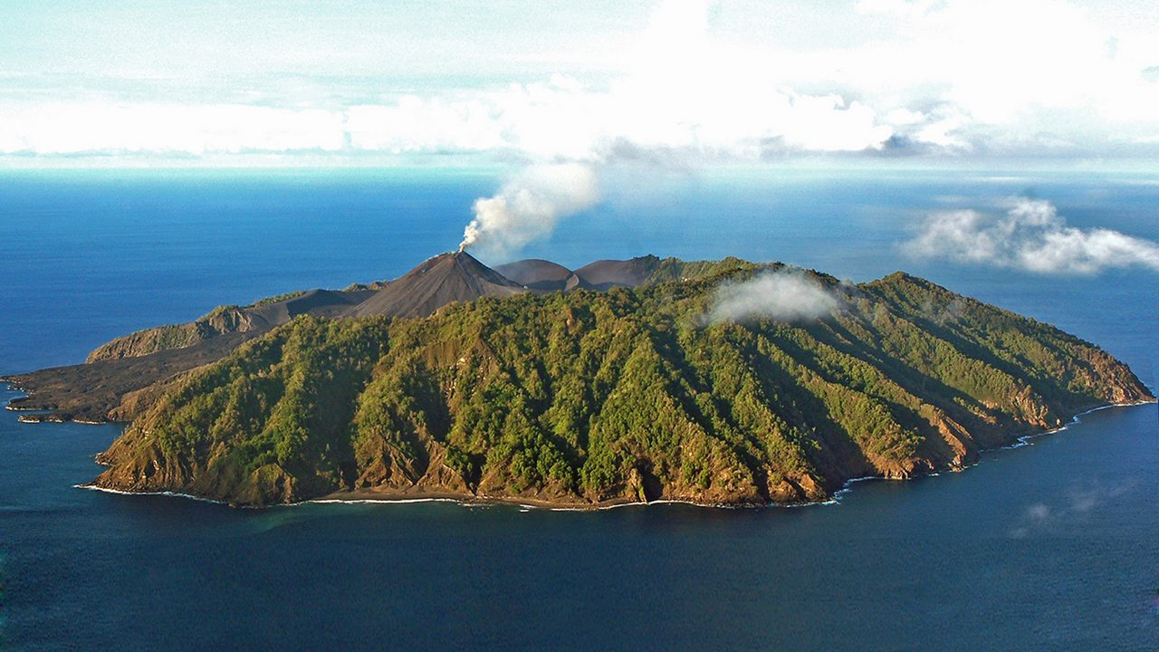
India has no volcanoes in the Himalayan region or the Indian peninsula. However, Barren Island, located in the Andaman and Nicobar Islands, is the only active volcano in India. It became active in the 1990s and was confirmed as an active volcano after spewing lava and ash in 2017.
Another volcanic island in Indian territory is Narcondam, situated about 150 km northeast of Barren Island. It is considered extinct, as its crater wall has been destroyed.
Impacts of Volcanic Eruptions :
Destructive Effects of Volcanism
Volcanic eruptions can cause massive destruction. Lava flows can cover entire cities, destroying homes, roads, and natural landscapes. The falling of hot rocks and ash can harm people and animals.
Earthquakes linked to volcanic activity can shake the ground violently, while heavy rain can mix with volcanic ash to form mudflows that bury nearby areas. Sometimes, volcanic ash settles due to rain, covering large regions and making life difficult.
After an eruption, people may suffer from health problems like breathing issues, burns, and injuries from slippery roads. Volcanic activity can also reduce water quality, harm crops, and damage vegetation.
In coastal areas, underwater volcanic activity can trigger tsunamis, which cause widespread destruction.
Positive Effects of Volcanism
Despite its dangers, volcanism also has several benefits. It helps form new landforms such as islands, plateaus, and volcanic mountains. Example: The Deccan Plateau and Mount Vesuvius.
Volcanic ash and dust make the soil very fertile, which helps farmers grow crops. Even volcanic rocks break down over time to form nutrient-rich soil. Though steep volcanic slopes are unsuitable for farming, they support forests that provide valuable timber.
Volcanoes bring important minerals like copper and diamonds to the surface. Example: The kimberlite rock of South Africa, which is a source of diamonds.
Lava rocks are widely used in construction, such as for making concrete and railway tracks.
In volcanic areas, underground water gets heated by magma, forming hot springs and geysers. This heat is used to produce geothermal energy, which is an important source of electricity in countries like the USA, Russia, Japan, Italy, New Zealand, and Mexico.
Many volcanic areas also attract tourists, boosting local economies. Some volcanoes have been turned into national parks to protect their beauty and wildlife.
Conclusion
Volcanism is a dynamic geological process that has played a crucial role in shaping the Earth’s landscape. While it poses serious hazards, it also creates fertile land and contributes to planetary evolution. Continued research and monitoring are essential for mitigating volcanic risks and understanding Earth’s internal processes
UPSC Prelims PYQs (2018)
1. Consider the following statements :
- The Barren Island volcano is an active volcano located in the Indian Territory.
- Barren Island lies about 140 km east of Great Nicobar.
- The last time the Barren Island volcano erupted was in 1991, and it has remained inactive since then.
Which of the statements given above is/are correct?
- 1. Only
- 2 and 3 Only
- 3 Only
- 1 and 3 Only
Answer : A
The Barren Island volcano is an active volcano located in the Indian Territory : Correct. Barren Island is India’s only active volcano, situated in the Andaman and Nicobar Islands
Barren Island lies about 140 km east of Great Nicobar: Incorrect. Barren Island is approximately 140 km northeast of Port Blair, not Great Nicobar.
The last time the Barren Island volcano erupted was in 1991, and it has remained inactive since then : Incorrect. After a dormant period of over 150 years, Barren Island erupted in 1991 and has exhibited intermittent activity since then, with eruptions reported in 1995, 2005, 2017, and 2022
UPSC MAINS PYQ –
Mains (GS Paper I – Geography)
- Discuss the natural resource potential of the ‘Deccan Trap’ (2022)
- Mention the global occurrence of volcanic eruptions in 2021 and their impact on the regional environment (2021)
- Discuss the geophysical characteristics of the Circum-Pacific Zone. (2020)
FAQs for Volcano
What is a volcano?
What is a volcano?
A volcano is a geological feature where molten rock, ash, and gases escape from beneath the Earth’s surface, often leading to eruptions.
What causes volcanic eruptions?
Volcanic eruptions are primarily caused by the buildup of pressure from molten magma beneath the Earth’s crust.
Are all volcanic eruptions explosive?
No, volcanic eruptions can range from relatively quiet effusive eruptions to highly explosive ones, depending on factors like magma viscosity and gas content.
How are earthquakes measured?
Earthquakes are measured using seismometers, and their magnitude is typically quantified on the Richter scale or the moment magnitude scale (Mw).
What is the difference between the epicenter and the focus of an earthquake?
The epicenter is the point on the Earth’s surface directly above the earthquake’s point of origin, known as the focus or hypocenter.
Can earthquakes be predicted?
- Predicting the exact time and location of earthquakes remains highly challenging, but scientists can identify areas with a higher risk of seismic activity based on historical data and fault lines.