Landforms, found throughout the world, exhibit a remarkable array of physical characteristics. These characteristics encompass their unique shapes, sizes, and constituent materials. The origins of landforms are fascinating narratives woven by geomorphic processes and natural agents.
Every landform has its own story of how it came into existence, with its beginnings rooted in the complex interplay of geological processes and the actions of various natural agents.
These landforms are far from static; they continually undergo changes. These alterations can happen gradually or rapidly, depending on the influences of geomorphic processes and the actions of natural agents.
The evolution of landforms is shaped by a variety of factors. Climatic conditions play a significant role, influencing both the intensity and nature of geomorphic processes. Additionally, the movements of the Earth’s crust, whether vertical or horizontal, exert a profound impact on landforms, leading to modifications and transformations in the landscape.
The Earth’s surface is an ever-changing canvas where the forces of nature continually create, shape, and redefine landforms. This ongoing process showcases the dynamic nature of our planet’s geomorphic processes and their enduring impact on the physical features that make up our world.
Defination of landforms
A landform refers to a region of the Earth’s surface, typically ranging from small to medium-sized, and landscapes are the amalgamation of interconnected landforms. Each landform possesses its own unique physical attributes, including dimensions, composition, and shape, shaped by distinct geomorphic forces at play.
The majority of geomorphic processes and the agents responsible for them operate at a gradual pace, requiring time for their effects to become noticeable. Every landform has an initial point of formation, and once established, it has the capacity to undergo gradual or rapid alterations in terms of size, configuration, and inherent characteristics. These changes occur due to the ongoing influence of geomorphic processes and various agents.
The Process of Transformation
Evolution denotes a sequence of changes involving the transformation of either a portion of the Earth’s surface from one type of landform to another or the alteration of individual landforms after their initial formation. Essentially, this suggests that each landform has a unique developmental history, undergoing various modifications over time.
In a way, the evolution of landforms can be likened to the stages of life, where a landmass progresses through phases of development that parallel youth, maturity, and old age.
Geomorphic Forces: Shaping the Earth’s Surface
The Earth’s surface undergoes continuous transformations, primarily driven by the relentless actions of various geomorphic agents. These agents, which include running water, groundwater, glaciers, wind, and waves, are instrumental in both eroding and depositing materials across the landscape. They play a pivotal role in shaping and altering the Earth’s surface features.
- Running Water: Rivers and streams carve intricate patterns as they flow, sculpting valleys, canyons, and riverbanks over time. They carry sediments, contributing to the creation of floodplains and deltas.
- Groundwater: Underground water sources slowly dissolve and transport minerals, contributing to the formation of caves and unique underground landscapes.
- Glaciers:Massive sheets of ice creep across the land, carving out deep valleys and fjords, as well as depositing sediments and moraines as they advance and retreat.
- Wind: Wind can erode exposed surfaces, creating sand dunes in deserts and shaping rock formations through abrasion. It also plays a role in transporting fine particles over long distances.
- Waves: Coastal waves constantly reshape shorelines, forming beaches, spits, and barrier islands, while also eroding cliffs and coastal features.
These geomorphic agents don’t act in isolation. They work alongside weathering processes (physical, chemical, and biological) and mass wasting events (landslides, rockfalls) to bring about changes in the Earth’s surface.
What makes these transformations even more intriguing is their long-term impact. Over extended periods, these geomorphic agents instigate systematic changes, leading to the sequential development of landforms. As a result, the Earth’s surface is an ever-evolving canvas, displaying the intricate interplay of geological forces that shape our planet’s remarkable landscapes.
Main of Landforms on Earth
The Earth’s surface is far from uniform; it boasts an array of textures, with some areas appearing rugged while others are characterized by a smoother quality. This natural diversity of landforms is virtually boundless, contributing to the planet’s unique topography.
Internal Forces: Shaping the Earth’s Contours
Internally driven processes play a pivotal role in the dynamic evolution of the Earth’s surface. These processes cause the rise and fall of landforms, sculpting the landscape in remarkable ways.
External Forces: The Ongoing Reshaping
Simultaneously, external forces continuously reshape the land surface through two prominent processes: erosion and deposition. These processes are instrumental in the formation and alteration of landforms, actively participating in the Earth’s geological narrative.
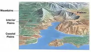
Based on their distinctive characteristics such as slope and elevation, landforms can be classified into several categories, including:
- Mountains
- Plains
- Plateaus

Mountains
A mountain, a prominent geological feature, rises as an elevated portion of the Earth’s crust, often revealing steep sides and significant exposed bedrock. In comparison to hills, mountains are larger and distinguish themselves from plateaus by their elevation, typically soaring at least 300 meters (1000 feet) above the surrounding terrain. They also tend to have relatively smaller peak areas. While most mountains are part of extensive mountain ranges, a few stand as solitary summits.
Fold Mountains
The formation of fold mountains occurs when Earth’s tectonic plates forcefully collide, compelling rocks and debris to bend and shape into rugged cliffs, hills, peaks, and extensive mountainous regions at these converging boundaries. Fold mountains are often intimately connected with continental crusts. Notable examples include the Himalayas and the Alps.
Block Mountains
Block mountains take shape when the central block, situated between two normal faults, ascends. These rising blocks are also known as “horsts.” Although the surface of the block mountain’s summit area can appear relatively smooth, the side elevations are typically characterized by steep terrain. Examples include the Rhine Valley and the Vosges in Europe.
Volcanic Mountains
Volcanic mountains emerge as a result of volcanic activity on the Earth’s surface. Magma from within the planet rises through surface fractures, eventually erupting as lava. The repeated cooling of this lava gives rise to the formation of volcanic mountains. Notable examples include Mount Kilimanjaro in Africa and Mount Fujiyama in Japan.
Each type of mountain offers a unique geological story, reflecting the dynamic processes and forces that have shaped these awe-inspiring landforms over time.
Advantages of mountain landforms
- Water Source:Mountains are like nature’s water towers. They often host glaciers, which serve as natural reservoirs. As the glaciers gradually melt, they release freshwater, giving rise to numerous rivers. These rivers are essential sources of clean water, sustaining communities, agriculture, and industries downstream.
- Hydroelectric Power:The flowing rivers that originate in mountainous regions are a gift for the energy sector. Hydroelectric power plants strategically placed along these rivers harness the kinetic energy of flowing water to generate electricity. This clean and renewable energy source helps power homes, businesses, and industries while reducing reliance on fossil fuels.
- Irrigation:Agriculture is the backbone of many societies, and mountain-fed rivers play a crucial role in sustaining crops. Through well-planned irrigation systems, water from these rivers is distributed to arable lands, ensuring the growth of essential crops and food security for communities downstream.
- Biodiversity:Mountains are biodiversity hotspots, home to a rich tapestry of plant and animal life. The varying elevations, climates, and ecosystems within mountains support a diverse array of species. From rare alpine plants to elusive mountain goats, these environments foster ecological diversity and provide invaluable habitats for countless creatures.
- Natural Resources:The woodlands nestled within mountainous regions offer a wealth of natural resources. Timber harvested from mountain forests serves as a vital material for construction, providing shelter and infrastructure for communities. Moreover, these forests yield firewood and other forest products like raisins and gum, meeting both practical and economic needs.
- Scenic Beauty: Beyond their utilitarian roles, mountains beckon travelers with their stunning beauty. The towering peaks, lush valleys, and pristine lakes create awe-inspiring landscapes that offer solace and rejuvenation to visitors. Whether for recreation, adventure, or simply contemplation, mountains provide a serene escape from the hustle and bustle of urban life.
Mountainous landforms are true treasures, not only for their practical contributions to water resources, energy, and agriculture but also for their role in sustaining biodiversity and offering natural beauty that enriches the human spirit.
Plains
Plains stand as some of the most prominent landforms on the Earth’s surface. Characterized by their low-lying, gently sloping terrain and minimal local relief, these expansive landscapes cover approximately 55% of the planet’s land area. Their creation owes much to various natural processes.
Formation
The formation of plains is a testament to the relentless forces of nature. Many plains have their origins in the deposition of sediments by rivers. However, they owe their existence to more than just rivers. Wind, shifting glaciers, and tectonic activity have also played pivotal roles in shaping some of these flat expanses.
Some of the most extensive plains on Earth have been shaped by the patient work of rivers. Notable examples include the vast plains found in Asia and North America, which owe their existence to the tireless efforts of rivers.
Asia
The Ganga and Brahmaputra rivers in India, along with the Yangtze River in China, have been instrumental in the creation of expansive plains across Asia, sustaining diverse ecosystems and providing fertile land for agriculture.
Benefits of Plains Landforms
Agriculture Hub
Plains are often considered the breadbaskets of the world. They offer ideal conditions for agriculture, with expansive grasslands providing excellent grazing areas for cattle and deep, fertile soils that can be efficiently mechanized for crop production. This agricultural potential is vital for food production and sustenance.
Population Centers
Many of the world’s most densely populated regions are located on plains. For example, the Indo-Gangetic plains of India, with their fertile soils and abundant water resources, support high population densities. These plains become centers of economic activity, culture, and civilization.
Plains are not only foundational to agriculture but also to human habitation and the prosperity of nations, playing a pivotal role in the sustenance and development of societies across the globe.
Plateau
A plateau, also known as a tableland or high plain in the realms of geology and physical geography, is a distinctive landform. It is characterized by its flat, elevated expanse, often abruptly rising above the surrounding terrain, creating a remarkable topographical feature. Typically, plateaus are bounded by steep hills or cliffs on one or more sides, setting them apart from the lower-lying regions around them.
Plateaus can be found on every continent, each with its own geological history and unique attributes. Some remarkable examples include:
- India’s Deccan Plateau: Renowned as one of the oldest plateaus on Earth, the Deccan Plateau in India spans a vast area and features diverse landscapes.
- Australia’s Western Plateau:The Western Plateau, an extensive high plain in Australia, showcases a range of geological formations and is home to unique flora and fauna.
- Kenya’s East African Plateau:Nestled in Kenya, this plateau combines breathtaking natural beauty with cultural significance, attracting tourists and researchers alike.
- Tibetan Plateau: Often referred to as the “Roof of the World,” the Tibetan Plateau stands as the highest and largest plateau globally, known for its extreme elevation and unique ecosystems.
Benefits of Plateau Landforms:
- Mineral Wealth
Plateaus often harbor a wealth of minerals beneath their surfaces. These minerals, including metals and ores, are essential raw materials for various industries, such as mining, metallurgy, and construction. Plateaus serve as critical resource reservoirs, driving economic activities and industrial development.
- Agricultural Resources
Some plateaus, particularly those formed through volcanic processes, offer fertile black soils that are well-suited for agriculture. These regions support food production and agricultural enterprises, contributing to local and global food supplies.
- Tourist Attractions
Many plateaus, with their unique geological formations, diverse ecosystems, and stunning landscapes, draw tourists and nature enthusiasts. These elevated terrains provide opportunities for outdoor activities, wildlife observation, and cultural experiences, making them significant contributors to local economies.
Plateaus are not merely geological formations but dynamic landscapes that play pivotal roles in mineral resource extraction, agriculture, and tourism, enriching both the environment and human society.
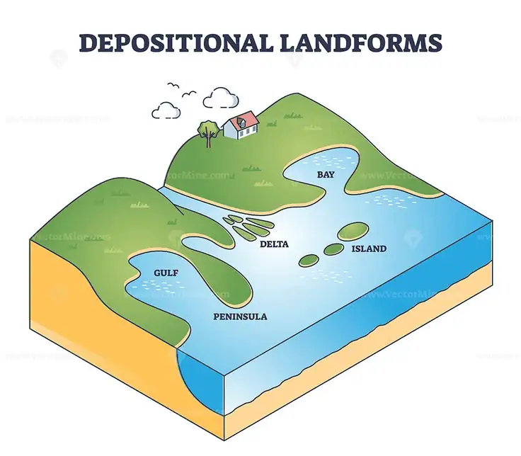
Depositional Landforms

- Moraines
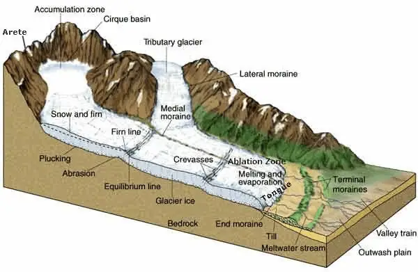
Moraines are extensive landforms formed as a result of glacial processes. They are essentially long ridges comprised of glacial till, a heterogeneous mix of rocks, sediment, and debris that glaciers transport and deposit. Terminal moraines are notable features, extending across the glacier’s terminus or toe. Lateral moraines, on the other hand, develop parallel to glacial valleys. In some cases, lateral moraines converge with terminal moraines, forming a distinctive horseshoe-shaped ridge. Additionally, ground moraines are characterized by their variable thickness and surface topography, representing the widespread deposition of glacial material over a broader area. These moraines are enduring markers of past glacial activity, offering insights into the history of ice sheets and their movements.
- Eskers
Eskers are intriguing depositional landforms with their origins rooted in the seasonal melting of glaciers, particularly during summer. As glaciers melt, water accumulates beneath the ice and flows in channels beneath its frozen surface. These sub-glacial streams, containing a mixture of coarse materials like boulders, blocks, and minor rock debris, deposit sediments along their paths. Once the glacier retreats and the ice melts away, these sediments remain as sinuous ridges known as eskers. What distinguishes eskers is their ice-formed banks, which create distinct raised pathways in the landscape. These formations are relics of the glacier’s movement and the processes that took place beneath it.
- Outwash Plains
At the foot of glacial mountains or beyond the limits of continental ice sheets, one can encounter expansive outwash plains. These plains are characterized by the presence of glacio-fluvial deposits, typically in the form of broad, flat alluvial fans. These fans may merge to form extensive outwash plains, composed of a mix of materials such as gravel, silt, sand, and clay. These deposits result from the dynamic interplay between glacial meltwater and the surrounding landscape. Outwash plains are vital for understanding the influence of glacial activity on downstream environments and the complex interrelationships between geological processes and landforms.
- Drumlins
Drumlins are distinct landforms shaped by glacial processes, characterized by their smooth, oval-shaped, and ridge-like appearance. These formations are primarily composed of glacial till, a combination of unsorted rock fragments, sediments, and debris carried and deposited by glaciers. Drumlins align themselves parallel to the direction of ice movement, serving as valuable indicators of past glacial flow. Their sizes can vary significantly, with some drumlins extending up to a kilometer in length and reaching heights of approximately 30 meters. These landforms hold clues to the glacial history of an area and offer insights into the dynamics of ice sheets and their impact on the landscape.
Arid Landforms

In the unforgiving landscapes of hot deserts, the dominant geological force at play is the relentless power of the wind. Wind, over countless years, has been a sculptor of remarkable landforms, both through the process of erosion and deposition, creating some of the most distinctive features of arid regions.
Erosional Features
Ventifacts
One of the captivating results of wind action in deserts is the formation of ventifacts. These are rocks and boulders meticulously sculpted by wind-blown sand and abrasive particles. Over time, the wind carves intricate patterns, smoothes surfaces, and gives these natural sculptures their unique, polished appearance. Ventifacts stand as enduring monuments to the artistry of wind-driven erosion, bearing the marks of aeolian craftsmanship.
Yardangs
Wind is a patient artist, and nowhere is this more evident than in the creation of yardangs. These are elongated landforms, often resembling streamlined ridges and grooves. The wind, laden with sand and sediment, sculpts these features with relentless abrasion. Yardangs align themselves with the prevailing wind direction, their sinuous forms offering a testament to aeolian erosion’s enduring power.
Dunes
Perhaps the most iconic desert landform shaped by wind is the sand dune. Wind-blown sand accumulates over time to form towering dunes, some reaching impressive heights. Dunes come in a variety of shapes, including crescent-shaped barchan dunes, linear seif dunes, and complex, star-like star dunes. These dynamic features are the result of a delicate balance between wind-driven erosion and deposition, showcasing the ever-changing character of desert landscapes.
Depositional Features
Sand Sheets
In less sheltered areas of deserts, wind deposits sand in vast, flat sheets known as sand sheets. These expansive landscapes are often characterized by fine-grained, wind-swept sands that stretch as far as the eye can see. Sand sheets create a mesmerizing vista, reflecting the aeolian forces at work.
Loess Deposits
Wind carries fine silt and clay particles across the desert, eventually settling to create extensive loess deposits. These sediments, rich in nutrients, have a transformative effect on the desert soil. Loess-enriched soil can support agriculture, bringing life and fertility to otherwise barren expanses.
Playas
Wind-blown sand can accumulate around natural depressions in the desert terrain, forming shallow, dry lake beds known as playas. These intermittent features play a crucial role in desert ecosystems, serving as habitats for unique flora and fauna that have adapted to their challenging environment.
Desert Pavements
In areas with sparse vegetation cover, wind becomes a meticulous landscaper, gradually removing finer particles and leaving behind a surface known as a desert pavement. Composed of closely packed pebbles and stones, this protective layer stabilizes the soil, shielding it from further wind erosion. Desert pavements are a testament to nature’s capacity for adaptation and balance.
These remarkable landforms bear the indelible mark of wind’s influence on arid landscapes. Over time, wind has etched its signature across the desert terrain, creating a visual tapestry of mesmerizing features that both captivate the eye and tell the enduring story of aeolian forces shaping the world’s deserts.
Erosional Landforms

Pediments and Pediplains
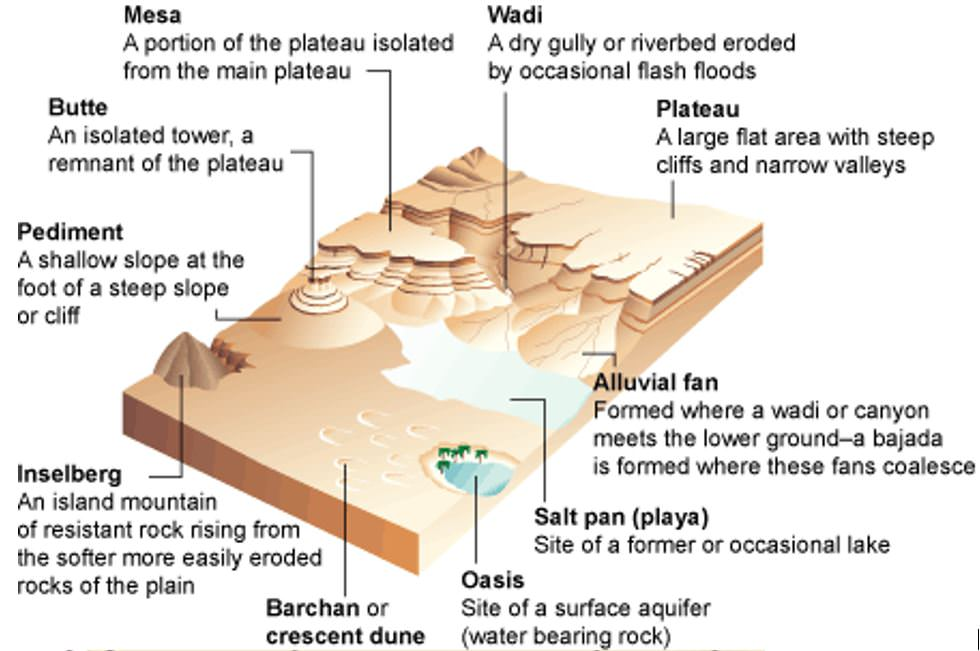
Pediments and pediplains are distinctive landforms found near the base of mountains in desert regions. These features consist of gently inclined rocky floors, sometimes covered by a thin layer of debris. Pediments evolve through the gradual retreat of slopes, extending backward at the expense of the mountain front. This ongoing process gradually reduces the size of the mountain, leaving behind a remnant known as an inselberg. Over time, the high relief of desert areas gives way to low, featureless plains known as pediplains.
Playas
Playas represent expansive plains and stand as some of the most prominent landforms in deserts. In times of sufficient water, these plains may be covered by a shallow water body. These shallow lakes, known as playas, typically retain water for a short duration due to the intense evaporation common in desert climates. Playas often contain significant deposits of salts due to the concentrated evaporation process.
Deflation Hollows and Caves
Deflation is a process driven by the persistent movement of wind currents in a single direction. Over time, this process can result in the removal of weathered material from the surface of rocks or bare soil, creating shallow depressions known as deflation hollows. Deflation can also create numerous small pits or cavities on rock surfaces, where the impact and abrasion of wind-borne sand contribute to their formation. Some of these depressions, initially called “blow outs,” may evolve into deeper and wider features that can be described as caves.
Mushroom, Table, and Pedestal Rocks
In desert environments, certain rock outcrops are particularly susceptible to wind deflation and abrasion. As the wind wears away these rocks, it often leaves behind remnants of more resistant rocks in distinctive shapes. Some of these formations resemble mushrooms, with slender stalks supporting broad, rounded caps. Others may feature broad, table-like surfaces, while some remnants stand out like pedestals, creating a unique landscape of sculpted rock formations.
Depositional Landforms:
Sand Dunes
Dry, hot deserts provide ideal conditions for the formation of sand dunes, and various factors play a role in their development. Wind speed, direction, and the presence of obstacles all influence the types of dunes that form. One common dune type is the barchan, characterized by its crescent shape with points or wings directed away from the prevailing wind. Parabolic dunes, on the other hand, form when sandy surfaces are partially covered by vegetation, essentially reversing the barchan shape while maintaining the same wind direction.
Seif dunes are similar to barchans but have only one wing or point, giving them a distinctive appearance. Longitudinal dunes emerge when the supply of sand is limited, and the wind direction remains constant. These dunes take the form of long ridges with considerable length but relatively low height. Transverse dunes, in contrast, align perpendicular to the wind direction. They typically form when the wind direction remains consistent, and a source of sand is elongated and oriented at right angles to the prevailing wind direction. These diverse dune forms contribute to the captivating and ever-changing desert landscapes.
What are landforms?
What are landforms?
Landforms are natural features and structures that make up the Earth’s surface. They encompass a wide range of physical features, including mountains, valleys, plains, plateaus, rivers, lakes, deserts, and more.
How are landforms created?
Landforms are created through various geological processes and forces. Some common processes include tectonic plate movements, erosion by wind and water, volcanic activity, sediment deposition, and glaciation. Over time, these processes shape and modify the Earth’s surface.
What is the importance of studying landforms?
The study of landforms, known as geomorphology, is essential for understanding the Earth’s history, processes, and environmental changes. It helps scientists and geologists decipher the Earth’s past, predict future changes, and assess natural hazards like earthquakes and landslides.
What are the major types of landforms?
Landforms can be broadly categorized into several types, including mountains, valleys, plateaus, plains, hills, canyons, and coastal features like cliffs, beaches, and dunes. Each type has its unique characteristics and formation processes.
How do landforms impact human activities?
Landforms play a significant role in shaping human civilizations. They influence settlement patterns, agriculture, transportation networks, and even cultural practices. For example, fertile plains are often ideal for farming, while mountainous regions may limit accessibility and development.