The formation of the Himalayas is the result of a dramatic collision between the Indian Plate and the Eurasian Plate. This collision is a geological process that unfolded over millions of years. During the Cretaceous period, the Indian subcontinent separated from the ancient supercontinent of Gondwana and began its northward drift.
Between the Indian Plate and the Eurasian Plate lay the Tethys Sea, which over time, due to the immense pressure from the converging plates, became squeezed and formed a geosyncline—a geological term referring to a down-bending, sediment-filled region between two tectonic plates.
As the Indian Plate continued its northward journey, the oceanic margin of the plate began to subduct beneath the Eurasian Plate. This subduction process led to intense volcanic activity, and some of the resulting rocks and geological features are still preserved in the Ladakh region of the Himalayas. These volcanic remnants offer valuable insights into the geological history of the Himalayas and the processes that shaped this majestic mountain range over millions of years.

The Himalayan Ranges
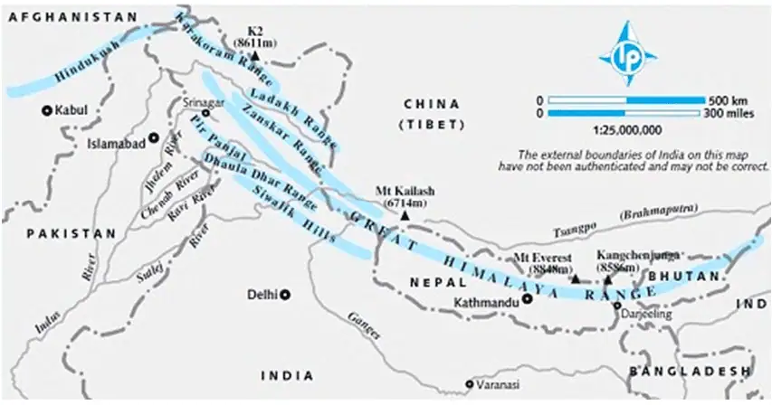
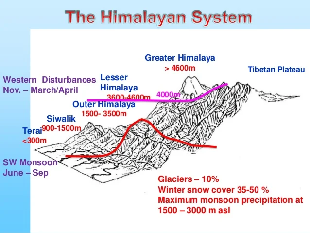
It is situated at the juncture of the Tibetan Plateau and the Indian subcontinent in Asia, the Himalayan mountain range serves as a natural boundary. These mountains can be categorized into three main ranges: the Inner Himalayas, the Middle Himalayas, and the Outer Himalayas. Among these, the northernmost range is referred to as Himadri or the Greater Himalayas.
Significance of the Himalayas for India:
- The Himalayas are a primary source of India’s mighty rivers, thanks to abundant rainfall, vast snowfields, and large glaciers. These rivers and their tributaries carry substantial amounts of alluvium, enriching the fertile plains of North India and making it one of the world’s most fertile regions.
- Approximately 33% of India’s thermal electricity and 52% of its hydropower depend on the rivers originating in the Himalayas. These rivers receive a significant portion of their water from melting glaciers, making them vital for India’s energy and water security.
- The Himalayas significantly influence India’s climate. Their high altitude, length, and direction intercept the summer monsoons from the Bay of Bengal and Arabian Sea, causing essential rainfall. They also act as a barrier, preventing cold air masses from Central Asia from entering India.
- The Himalayan ranges are rich in forest resources, showcasing a transition of vegetal cover from tropical to Alpine as altitude increases. These forests provide fuelwood and various raw materials for forest-based industries, including numerous medicinal plants.
- The Himalayas’ stunning natural beauty and healthy environment have led to the development of numerous tourist destinations. The hilly areas offer a pleasant climate, providing respite from the scorching summer heat in the neighboring plains.
Cyclones Anticyclones (Important For APSC): Himalayas ( Important for APSC)
Challenges Associated with the Himalayas in India:
- Inadequate Waste Management: Urban areas in the Himalayan region are grappling with issues such as mounting garbage, plastic pollution, untreated sewage, unplanned urban expansion, and even local air pollution caused by vehicles. Most mountain villages lack proper decentralized waste disposal facilities, leading to the burning or dumping of waste on the slopes.
- Unsustainable Tourism Practices: The Himalayan mountains are often regarded primarily as tourist destinations, with little consideration for the potential consequences of overexploitation of resources. This approach can have disastrous environmental effects. The mountains have unique microclimates and fragile ecosystems with species that reproduce within short timeframes, making them sensitive to disruption. Unsustainable tourism can disrupt the delicate natural balance.
- Climate Change Impact: Climate change is causing the melting of ice and snow in the Himalayas, resulting in the formation of new glacial lakes and the expansion of existing ones. This phenomenon raises the risk of glacial-lake outburst floods, with over 8,800 glacial lakes scattered across the Himalayan region, and more than 200 of them categorized as hazardous.
- Flawed Infrastructure Projects: While the development of hydroelectricity is vital for providing renewable energy and generating revenue for the state, poorly designed and constructed hydropower projects can exacerbate the impact of floods and other natural disasters in the region.
Major Physical Divisions of India:
The Himalayas (Young Fold Mountains)
- This region comprises the youthful fold mountains known as the Himalayas.
- It extends to Purvanchal and includes extensions like Arakan Yoma (Myanmar) and the Andaman and Nicobar Islands, although we treat the latter as islands.
- The Himalayas are the youngest and most geologically active landmass in India, characterized by frequent tectonic movements.
The Indo-Gangetic Plain (Monotonous Topography)
- Situated between the Peninsular Plateau and the Himalayas.
- This region is relatively youthful and exhibits a featureless, monotonous topography, making it susceptible to tectonic forces.
The Peninsular Plateau (Oldest and Most Stable Landmass)
- Encompasses South India, Central India, the Aravalli Range, Rajmahal Hills, Meghalaya Plateau, and the Kuchchh-Kathiawar region in Gujarat.
- It is one of the world’s oldest and most stable plateaus, characterized by its age and structural stability.
Coastal Plains (Formed by Fluvial Deposits)
Comprises the Eastern Coastal Plains and Western Coastal Plains.
– These plains formed due to the accumulation of sediments brought by rivers through fluvial deposits.
– Similar to the Peninsular Plateau, the Coastal Plains are highly stable.
The Indian Islands
- Divided into two major groups: Lakshadweep and the Andaman and Nicobar Islands.
- Lakshadweep, known as a hotspot, consists of atolls built up by coral reefs and has not experienced significant recent volcanism or tectonic activity. It is vulnerable to rising sea levels.
- The Andaman and Nicobar Islands are a continuation of the Arakan Yoma, with active volcanoes and ongoing tectonic activity.
These distinct physical divisions of India showcase the country’s diverse geological and geographical characteristics.
Division of the Himalayas
The Great Himalaya (Inner Himalaya or Himadri)

- Also referred to as the Inner Himalaya, Central Himalaya, or Himadri.
- It boasts an average elevation of around 6,100 meters above sea level and spans approximately 25 kilometers in width.
- Composed primarily of central crystalline rocks like granites and gneisses, overlaid by metamorphosed sediments such as limestone.
- The folds in this range are asymmetrical, with steep south slopes and gentle north slopes, creating a “hogback” topography.
- Terminates abruptly at the syntaxial bends, with one located at Nanga Parbat in the northwest and another at Namcha Barwa in the northeast.
- Home to some of the world’s tallest peaks, many of which are perpetually covered in snow and collectively known as the “eight-thousanders.”
- Notable regional names for Mount Everest include “Sagarmatha” (The Goddess of the Sky) in Nepal and “Chomlungma” (Mother of the World) in China (Tibet).
- Mount Everest was first located by George Everest, the then Surveyor General of India in 1841, and in 1852, it was officially recognized as the world’s highest peak by the Great Trigonometrical Survey of India.
Passes in the Greater Himalayas
- These passes are typically situated at altitudes higher than 4,570 meters above sea level and remain snowbound for much of the year.
- In Jammu and Kashmir, notable passes include the Burzil Pass and Zoji La.
- Himachal Pradesh features the Bara Lacha La and Shipki La, which is part of the Hindustan-Tibet Road connecting Shimla with Gartok in Western Tibet.
- Uttarakhand includes passes like Thaga La, Niti Pass, and Lipu Lekh.
- Sikkim is home to Nathu La and Jelep La, an important trade route connecting Kalimpong near Darjeeling with Lhasa in Tibet.
The Trans-Himalayas
- The Trans-Himalayas are situated immediately north of the Great Himalayan range and are often referred to as the Tibetan Himalaya due to their extensive presence in Tibet.
- Key subranges within the Trans-Himalayas include the Zaskar, Ladakh, Kailas, and Karakoram Ranges.
- Stretching for approximately 1,000 kilometers in an east-west direction, this region has an average elevation of around 3,000 meters above sea level.
- The Nanga Parbat, standing at 8,126 meters, is a significant peak located in the Zaskar Range.
- The Ladakh Range runs parallel to the Zaskar Range and features several peaks exceeding 6,000 meters.
- The Kailas Range in western Tibet is an extension of the Ladakh Range and includes Mount Kailas (6,714 meters), the source of the Indus River’s northern tributaries.
- The northernmost subrange of the Trans-Himalayas in India is the Great Karakoram Range, also known as the Krishnagiri Range, extending eastwards from the Pamir for about 800 kilometers. It houses some of the world’s greatest glaciers outside the polar regions, with peaks exceeding 5,500 meters in elevation. The renowned K2 (8,611 meters), also known as Godwin Austen or Qogir, is the second-highest peak globally and the highest peak in the Indian Union.
- The Ladakh Plateau lies to the northeast of the Karakoram Range, featuring various plains and mountains like Soda Plains, Aksai Chin, Lingzi Tang, Depsang Plains, and Chang Chenmo.
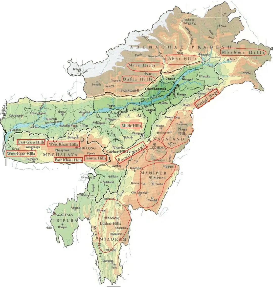
Purvanchal or Eastern Hills

- The Purvanchal, also known as the Eastern Hills, is a southward extension of the Himalayas along the northeastern edge of India.
- At the Dihang gorge, the Himalayas take a sudden southward bend and form a series of relatively low hills collectively called the Purvanchal.
- These hills have a westward convex shape.
- Stretching from Arunachal Pradesh in the north to Mizoram in the south, the Purvanchal hills serve as the border region between India and Myanmar.
- Notable features in this region include the Patkai Bum hills, the Naga Hills, Manipur hills, Barail Range, Jaintia, Khasi, Garo hills, and the Mizo Hills.
Syntaxial Bends of the Himalayas
- The Himalayas extend in an east-west direction from the Indus gorge in the west to the Brahmaputra gorge in the east.
- Sharp southward bends occur at these gorges, known as the syntaxial bends of the Himalayas.
- The western syntaxial bend is near Nanga Parbat, where the Indus River has carved a deep gorge.
- The eastern syntaxial bend is near Namche Barwa.
| Type of Topography | Extent in % |
| Mountainous (more than 2135 m above sea level) | 10.7 |
| Hilly area (305 – 2135 m above sea level) | 18.6 |
| Plateau (305 – 915 m above sea level) | 27.7 |
| Plains | 43 |
Himalayan Ranges
- Comprise a series of parallel or converging mountain ranges.
- Separated by deep valleys, resulting in a highly dissected topography, especially in the areas of plateaus or uplands.
- Display steep gradients on their southern slopes and gentler inclines on their northern sides. (Scaling Mount Everest is comparatively less strenuous from the northern approach, but China imposes restrictions, leading climbers to opt for the steeper southern route through Nepal.)
- Predominantly situated within the borders of India, Nepal, and Bhutan. The northern slopes extend into Tibet (Trans-Himalayas), while the westernmost portion stretches into Pakistan, Afghanistan, and Central Asia.
- The Himalayas between Tibet and the Ganga Plain consist of three parallel ranges.
Shiwalik Range (Outer Himalayas)

- Also recognized as the Outer Himalayas.
- Positioned between the vast Great Plains and the Lesser Himalayas.
- Elevations in this range vary from 600 to 1,500 meters.
- It extends over an impressive distance of 2,400 kilometers, running from the Potwar Plateau to the Brahmaputra valley.
- Characterized by steep southern slopes and gentler northern slopes.
– The width of the Shiwaliks fluctuates, spanning from 50 kilometers in Himachal Pradesh to less than 15 kilometers in Arunachal Pradesh.
– This range forms an almost continuous chain of low hills, except for an 80-90-kilometer stretch occupied by the valleys of the Tista River and Raidak River.
– Dense forests envelop the Shiwalik range from North-East India up to Nepal, although the forest cover diminishes westward from Nepal due to a reduction in rainfall (rainfall decreases from east to west across the Shiwaliks and Ganga Plains).
– The southern slopes of the Shiwalik range in Punjab and Himachal Pradesh exhibit a lack of substantial forest cover and are marked by a network of seasonal streams referred to as “Chos.”
– Valleys within this region are part of synclines, while the hills form part of anticlines or antisynclines.
| The Shiwaliks are known by different names in different areas | |
| Region | Name of Shiwaliks |
| Jammu Region | Jammu Hills |
| Dafla, Miri, Abor and Mishmi Hills | Arunachal Pradesh |
| The Dhang Range, Dundwa Range | Uttarakhand |
| Churia Ghat Hills | Nepal |
Middle or the Lesser Himalaya
- Positioned between the Shiwaliks in the south and the Greater Himalayas in the north.
- Runs almost parallel to both of these mountain ranges.
- Often referred to as the Himachal or Lower Himalaya.
- Extending over a length of approximately 2,400 kilometers, the Lower Himalayan ranges are 60-80 kilometers wide.
- Elevations within this region vary from 3,500 to 4,500 meters above sea level, with numerous peaks surpassing 5,050 meters and remaining snow-covered year-round.
- The Lower Himalayas are characterized by steep, barren southern slopes, which hinder soil formation, and gentler, forest-covered northern slopes.
- In Uttarakhand, the Middle Himalayas feature the Mussoorie and Nag Tibba ranges.
- The Mahabharat Lekh, located in southern Nepal, is a continuation of the Mussoorie Range.
- East of the Kosi River, including the Sapt Kosi, Sikkim, Bhutan, and the Miri, Abor, and Mishmi hills, represents the lower Himalayan region.
- The Middle Himalayan ranges are more accessible to human habitation and have been favored for the establishment of numerous Himalayan hill resorts, including Shimla, Mussoorie, Ranikhet, Nainital, Almora, and Darjeeling.
Important Ranges of the Lesser Himalayas
Region
- The Pir Panjal Range: Located in Jammu and Kashmir to the south of the Kashmir Valley.
- The Dhaola Dhar Range: Situated in Himachal Pradesh.
- The Mussoorie Range and The Nag Tibba Range: Found in Uttarakhand.
- Mahabharat Lekh: Extends into Nepal.
The Pir Panjal Range
- The longest and most significant range in Kashmir, extending over 300 kilometers from the Jhelum river to the upper Beas river.
- It reaches elevations of up to 5,000 meters and primarily consists of volcanic rocks.
- Notable passes in the Pir Panjal range include the Pir Panjal Pass (3,480 meters), Bidil (4,270 meters), Golabghar Pass (3,812 meters), and Banihal Pass (2,835 meters).
- The Banihal Pass serves as a crucial transportation route, accommodating the Jammu-Srinagar highway and Jammu-Baramula railway.
- The Kishanganga, Jhelum, and Chenab rivers traverse this range.
- To the southeast of the Ravi River, the Pir Panjal continues as the Dhaola Dhar range, passing through areas like Dalhousie, Dharmshala, and Shimla.
Important Valleys:
- Between the Pir Panjal and the Zaskar Range of the main Himalayas lies the valley of Kashmir, characterized by an average elevation of 1,585 meters above sea level.
- The valley floor is covered with deposits such as alluvial, lacustrine (lake deposits), fluvial (river action), and glacial deposits. The Jehlum River meanders through these deposits, cutting a deep gorge in the Pir Panjal range through which it drains. (Kashmir resembles a basin with limited outlets).
- Himachal Pradesh is home to the Kangra Valley, a strike valley extending from the base of the Dhaola Dhar Range to the south of the Beas River.
- Conversely, the Kulu Valley in the upper course of the Ravi River is a transverse valley.
Strike valley vs. Transverse valley
- A strike valley runs perpendicular to the slope or parallel to the ridge (also known as a longitudinal valley).
- In contrast, transverse valleys are formed when streams cut valleys parallel to the slope, following the dip of the terrain.

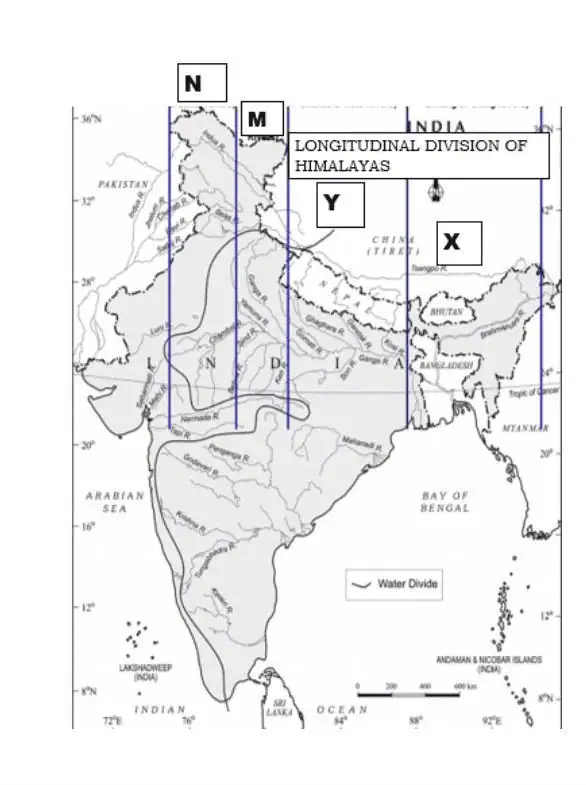
Longitudinal Division of the Himalayas
The Himalayas, home to the world’s tallest peaks, stand as a remarkable mountain range in Asia, forming a formidable barrier between the Tibetan Plateau to the north and the fertile alluvial plains of the Indian subcontinent to the south. Geographically, it is divided into five longitudinal divisions, spanning from west to east.

Division of the Himalayas from West to East
The Kashmir/Punjab/Himachal Himalayas
- Extending between the Indus River and Sutlej, this division is a significant part of the Himalayan range, spanning Jammu and Kashmir and Himachal Pradesh. It is also referred to as the Punjab Himalayas.
- In Jammu and Kashmir: Characterized by towering snow-covered peaks, deep valleys, intricate spurs, and high mountain passes. It covers a length of 700 kilometers and a width of 500 kilometers, with elevations reaching 3,000 meters and numerous glaciers. Ladakh, within this region, experiences cold desert conditions. The Kashmir valley, surrounded by the Greater and Lesser Himalayas, is known for its Karewa soil and cultivation of saffron and dry fruits.
- Important passes in the Kashmir Himalayas include Pir Panjal, Banihal, Zoji La, Burzil, Khardungla, Pensi-La, Saser-La, Lanak-La, Jara-La, Tasaka-La, Umasi-La, and Qara-Tagh-La. Prominent snow-capped peaks include Nanda Devi, Trisul, Nunkun, Kamath, and Nanga Parbat.
- In Himachal Pradesh: All three Himalayan ranges (Greater, Lesser, and Outer) are well-represented. Northern slopes are adorned with lush forests, plains, and lakes, while the southern slopes are rugged and forested. Notable areas in this region are the Kangra Valley, Kullu-Manali, Dalhousie, Shimla, Chamba, and Dharamsala. Key passes include Rohtang Pass, Bara-Lacha, and Shipki La.
The Kumaun Himalayas
- Situated between the Satluj and Kali Rivers, with Nanda Devi as its highest peak. Other notable peaks include Trisul, Kedarnath, Dunagiri, Kamet, Badrinath, Jaonli, Gangotri, and Bandarpunch. Prominent glaciers include Pindari, Gangotri, and Milam.
- Major hill stations in this region include Mussorie, Nainital, Ranikhet, Almora, and Bageshwar. Key passes are Thaga La, Muling La, Mana, Mangsha Dhura, and Lipu Lekh.
The Central/Nepal Himalayas
- Stretching from the Kali River to the Tista River, with most of it in Nepal, except for the eastern part, Sikkim Himalayas. Prominent peaks include Mt. Everest, Kanchenjunga, Makalu, Dhaula Giri, Annapurna, Manaslu, and Gosainath. Important passes are Nathu La and Jelep La.
The Assam/Eastern Himalayas
- This division occupies the area between the Tista and Brahmaputra Rivers (Dihang) and covers Arunachal Pradesh in India and Bhutan. It extends southward to encompass Nagaland, Manipur, Mizoram, and Tripura, known as Purvanchal.
- The Himalayas rise rapidly in the plains of Assam and narrow at the foothills of the Shiwaliks. It includes various hills such as Aka hills, Dafla hills, Miri hills, Abor hills, Mishmi hills, and Namcha Barwa. Notable hills in the eastern Himalayas are Pakai Bum, Manipur hills, Blue Mountain, Tripura range, and Barail range. Important passes in this region include Bomdi La, Yonggyap, Diphu, Pangsau, Tse La, Dihang, Debang, Tunga, and Bom La. The Purvanchal region is joined by the Meghalaya Plateau to the west, and its extension continues into the Myanmar mountain chain, ultimately reaching the Andaman and Nicobar Islands and the Indonesian Archipelago.
1. What are the Himalayas?
The Himalayas are a vast mountain range in Asia, spanning several countries including India, Nepal, Bhutan, China, and Pakistan. They are known for hosting some of the world’s highest peaks.
2. How were the Himalayas formed?
The Himalayas were formed due to the tectonic collision between the Indian Plate and the Eurasian Plate. This collision caused the Earth’s crust to fold and uplift, giving rise to these towering mountains.
3. What is the highest peak in the Himalayas?
The highest peak in the Himalayas and the world is Mount Everest, known as “Sagarmatha” in Nepal and “Chomolungma” in Tibet, China. It stands at 8,848 meters (29,029 feet) above sea level.
4. How many divisions are there in the Himalayas?
The Himalayas are traditionally divided into five main divisions from west to east: Kashmir/Punjab/Himachal Himalayas, Kumaun Himalayas, Central/Nepal Himalayas, Assam/Eastern Himalayas, and Trans-Himalayas.
5. What is the significance of the Himalayas for India?
The Himalayas are of great significance for India as they are the source of major rivers like the Ganges, Brahmaputra, and Indus, providing water for agriculture and hydropower. They also influence India’s climate and serve as a vital barrier.
6. What are some famous passes in the Himalayas?
The Himalayas are home to numerous mountain passes, including the Pir Panjal Pass, Zoji La, Rohtang Pass, Nathu La, and many others. These passes have historical and strategic importance