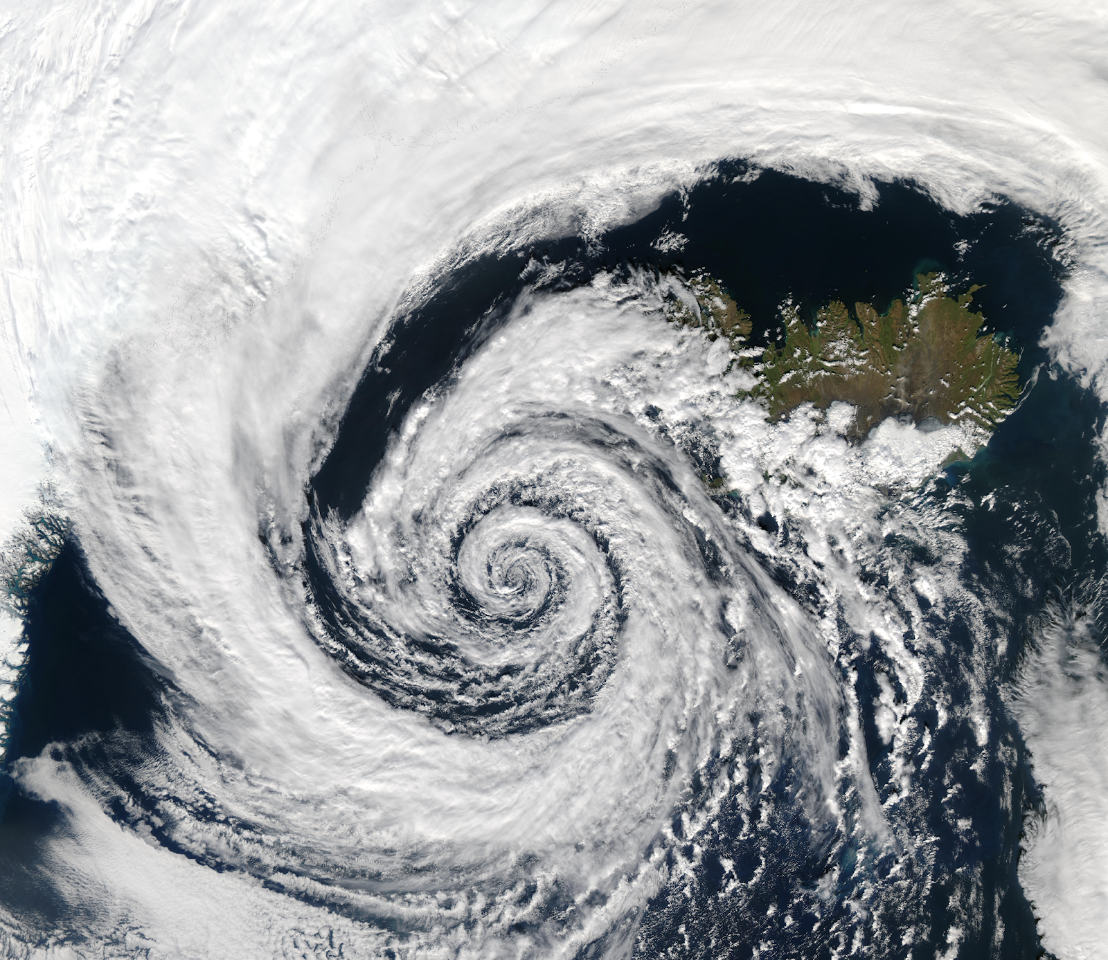
Cyclones Anticyclones emerge as a result of perturbations in the atmospheric conditions surrounding areas of low pressure, characterized by swift and often forceful air circulation. These phenomena give rise to intense storms and adverse climatic manifestations. Notably, cyclonic motion takes on an anticlockwise pattern in the Northern Hemisphere and a clockwise configuration in the Southern Hemisphere.
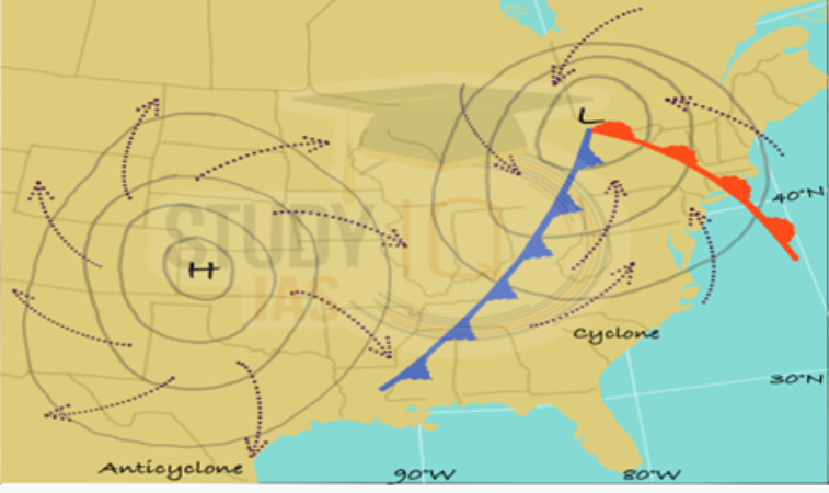
An anticyclone is a meteorological phenomenon characterized by expansive wind circulation encircling a central zone of heightened atmospheric pressure. In the Northern Hemisphere, this circulation follows a clockwise direction when observed from above, while in the Southern Hemisphere, it manifests in a counterclockwise manner (diametrically opposite to a cyclone). Surface-based anticyclones yield observable impacts such as sky clearance and the introduction of cooler, drier air masses. Furthermore, within areas marked by elevated pressure, nighttime fog formation is also known to occur.
The term ‘Tropical Cyclone,’ as defined by the World Meteorological organisations (WMO, 1976), pertains to weather systems with wind speeds surpassing ‘Gale Force’ (a minimum of 34 knots or 63 kph). These cyclones originate from the synergy of oceanic and atmospheric conditions, drawing strength from the sea’s heat. They are propelled by the interplay of easterly trade winds and temperate westerlies, influenced by robust global wind patterns and their own formidable internal energy.
Definition of cyclone

A cyclone is a sizable body of air that revolves around a potent center of decreased atmospheric pressure. In the Northern Hemisphere, this rotation is counterclockwise when observed from above, while in the Southern Hemisphere, it is clockwise. Cyclones exhibit winds that spiral inward, encircling an area of diminished pressure.
Definition of Anticyclone

An anticyclone refers to a region of elevated air pressure (exceeding 1013 Pa), where the atmospheric pressure surpasses that of its surroundings, and ascends from the outer edges toward the center. Typically, this phenomenon corresponds with unclouded skies, sunny conditions, and consistent weather patterns. Within the anticyclone’s vertical column, the air displays greater stability compared to its neighboring atmosphere. Consequently, the descending air prompts a process known as subsidence, which inhibits the occurrence of precipitation. It’s important to consider that the manner in which the air descends varies between the hemispheres.
Anticyclone formation
- Following the departure of a cyclone, an active anticyclone emerges over a specific location within the cold air region that succeeds it.
- This anticyclone’s formation anticipates the arrival of the subsequent cyclone and is commonly known as a cold anticyclone.
- In contrast, the descending air within an anticyclone undergoes compression.
- Compression leads to an elevation in air temperature, resulting in warming.
- The warmed air within the anticyclone, situated at altitudes ranging from 2 to 5 km (1 to 3 miles) above ground level, gradually heats up over time.
- Consequently, the anticyclone transforms from a cold to a warm state due to the warming of the air.
- Warm anticyclones can persist for approximately one week or even longer, exhibiting a lasting influence.
- A limited number of these blocking anticyclones have the potential to significantly reshape an entire season’s course.
- Regions like Europe, the eastern Atlantic, and Alaska are particularly susceptible to the occurrence of sun-blocking anticyclones.
- These anticyclones obstruct sunlight and can have substantial ramifications for weather patterns and conditions in the affected areas.
Types of cyclone:
- Extratropical cyclones Temperate cyclones or wave cyclones
- Tropical cyclones
- Extratropical cyclones Temperate cyclones or wave cyclones

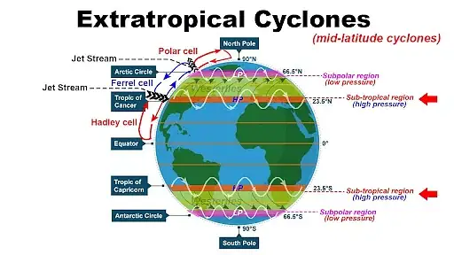
Temperate cyclones, also known as extratropical cyclones or wave cyclones, are areas of low atmospheric pressure that form in the mid-latitudes during the winter months in both the Northern and Southern Hemispheres.
These cyclones originate in regions between 35 to 65 degrees of latitude in both hemispheres. They emerge as a result of the convergence of two distinct air masses with differing properties.
Their occurrence is most prominent and intense during winter due to the significant temperature contrast at that time.
The polar front theory is a framework that elucidates the genesis of temperate cyclones. According to this theory, the creation of a front is a prerequisite for the development of temperate cyclones. As such, the conditions necessary for front formation are also essential for the birth of these cyclones:
- Presence of two opposing air masses with distinct temperature, pressure density, and humidity characteristics.
- Movement of the two air masses in opposite directions.
Temperate cyclones cover expansive areas, given their formation through the convergence of large and differing air masses. In certain instances, these cyclones can extend over an impressive expanse of approximately one million square kilometers.
The vertical extent of temperate cyclones reaches up to 10 kilometers above sea level in the upper troposphere.
Moisture present in warm, humid, and lighter air masses acts as the energy source for temperate cyclones. This moisture subsequently undergoes cooling, condensation, cloud formation, and precipitation. Because the energy source for these cyclones lies in the moisture present within warm air masses, they can emerge over both oceanic and continental surfaces.
Temperate cyclones, situated in the mid-latitudes, are primarily influenced by the prevailing mid-latitude permanent winds, known as the westerlies.
The movement of these cyclones is predominantly eastward from their point of origin, with an average speed of 32 km/h in summer and 48 km/h in winter.
The formation of temperate cyclones is a swift process that occurs through a series of successive stages:
- Convergence Stage: Two air masses with contrasting properties and directions converge.
- Incipient Stage: Warm and cold air masses intrude into each other’s domains, forming a wave-like front due to the Coriolis force.
- Mature Stage: The cyclone reaches its full development, with nearly circular isobars. This stage exhibits the highest energy and intensity, resulting in rainfall generated by different cloud types.
- Narrow Warm Sector Stage: The warm sector diminishes as the cold front advances, leading to a decline in the cyclone’s energy reservoir.
- Occlusion Stage: The advancing cold front overtakes the warm front, forming an occluded front. Rainfall and winds decrease further.
- Dissipation Stage: The warm sector disappears, the occluded front vanishes, and the cold air mass encompasses the area, leading to the eventual dissipation of the cyclone.
Compared to tropical cyclones, temperate cyclones are more predictable and occur regularly, primarily during the winter seasons.
WESTERN DISTURBANCES:
Wave cyclones that initiate over the Mediterranean Sea and Caspian Sea travel eastward guided by the subtropical westerly jet stream. These cyclones reach the northwestern regions of India in winter, resulting in snowfall across the Himalayan mountain ranges of Jammu and Kashmir, Himachal Pradesh, and Uttarakhand. Additionally, they bring rainfall to the plains of Punjab, Haryana, western Uttar Pradesh, Delhi, and northern Rajasthan, providing essential moisture for Rabi crops.
2. Tropical cyclones

Tropical cyclones manifest within the latitudinal range of 5 to 30 degrees in both the Northern and Southern Hemispheres. These formations are absent near or directly over the equator due to the absence of Coriolis force.
These are low-pressure atmospheric systems predominantly observed in low-latitude regions.
Cyclonic phenomena emerging between the Tropics of Capricorn and Cancer are known as tropical cyclones, marked by a non-uniform and irregular nature unlike the consistent extratropical or temperate cyclones.
The diverse array of cyclone types significantly varies in shape, size, velocity, and atmospheric conditions.
Distinct nomenclature for tropical cyclones exists across different global regions:
- Southeast Asia: Typhoons
- Caribbean Sea: Hurricanes
- Indian Ocean: Tropical cyclones
- Northeast coast of Australia: Willy Willies
The most potent and lethal type of cyclone in the Mississippi Valley of the USA is the tornado. These funnel-shaped storms, although small, are immensely violent and catastrophic. Their core exhibits extremely low pressure conditions. The steep pressure gradient prompts powerful winds to converge violently toward the center, reaching velocities of 600 to 800 km per hour. Tornadoes are heralded by dark, dense clouds, causing darkness, low visibility, and diminished air pressure.
Conditions conducive to tropical cyclone genesis encompass:
- A warm ocean surface with temperatures exceeding 27 degrees Celsius, which fuels thermal convection and robust warm, humid currents. This attribute often leads to the formation of tropical cyclones along the eastern coasts of continents influenced by warm ocean currents.
- The presence of the Inter Tropical Convergence Zone (ITCZ) enhances low-pressure intensification and augments moisture supply due to trade winds inflow.
- Coriolis force facilitates the deflection of dominant trade winds, inducing the circulatory system necessary for cyclone development. Absence of Coriolis force prevents tropical cyclone formation near the equator.
- Adequate atmospheric moisture serves as a source of latent heat of vaporization, fundamental for tropical cyclone energy.
- Minimal vertical wind shear to enable unobstructed upward airflow.
- Upper tropospheric air divergence.
Tropical cyclones encompass relatively smaller geographic areas but wield tremendous destructive potential. Their average diameters range from 80 to 300 km, occasionally shrinking to 50 km or less. However, they possess notable vertical extent, extending up to 15 km above sea level in the upper troposphere.
The primary energy source is the latent heat of vaporization inherent in warm and humid thermal convection currents. This latent heat subsequently drives cooling, condensation, cloud formation, and rainfall.
Their typical course follows an east-to-west trajectory, propelled by trade winds, leading to a general westward direction from their origin.
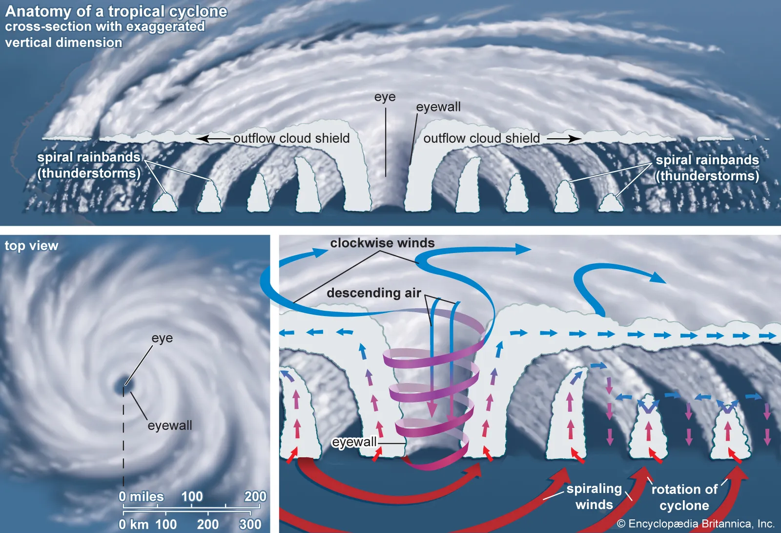
A fully developed tropical cyclone comprises:
- Eye: Characterized by the lowest pressure, the eye constitutes a high-temperature, high-humidity zone. It remains cloudless, windless, and rain-free.
- Inner Eyewall: The most destructive segment, marked by robust winds and intense rainfall generated through cumulonimbus clouds.
- Outer Eyewall: The outermost region with relatively lower wind velocity and rainfall intensity.
Tropical cyclones exhibit heightened vigor and velocity over oceans but weaken as they traverse land. Ultimately, they dissipate upon reaching the interior of continents, affecting primarily coastal regions.
Types of anticyclone
- Cold Anticyclones or Thermal Anticyclones:
- Warm Anticyclones or Dynamic Anticyclones:
- Blocking Anticyclones:
Cold Anticyclones or Thermal Anticyclones:
Cold anticyclones are atmospheric systems that originate above the Polar Regions as a result of descending air. The air subsides from higher altitudes, moving outward from the polar areas in easterly and southeasterly directions.
Warm Anticyclones or Dynamic Anticyclones:
Warm anticyclones are formed above warm subtropical regions. This happens when air sinks from the upper troposphere to the lower troposphere, leading to the divergence of air. As the air descends, it spreads out in different directions.
Blocking Anticyclones:
Blocking anticyclones emerge due to disruptions in the usual airflow patterns in the upper troposphere. These formations occur over mid-latitudes and are referred to as “blocking” because they obstruct the normal movement of temperate cyclones in those areas.
Anticyclones generally bring about consistent weather patterns. When air descends at the center of an anticyclone, the weather tends to become clear and devoid of rain. This is because the descending air leads to atmospheric stability, preventing the formation of clouds and precipitation.
Anticyclones have a significant impact on the weather of certain regions. The weather conditions in Canada, the USA, and northern Eurasia are often influenced by the presence of anticyclones. These systems play a role in determining whether the skies will be clear or cloudy and if there will be rain or dry conditions.
Anticyclones are regions of high atmospheric pressure where air descends from above. The different types of anticyclones arise from various mechanisms, and their effects on weather can vary, making them important features in understanding atmospheric processes and forecasting.
The color codes used by the IMD (Indian Meteorological Department) for cyclones convey different levels of alert and preparedness:
Colour code for cyclone by IMD
- Green: This color indicates a situation where everything is under control and no adverse weather conditions are expected. It signifies that everything is well and there is no cause for concern.
- Yellow: The yellow color code signifies the need for heightened awareness and preparedness. It suggests that security personnel and the public should stay updated and ready to manage potentially prolonged adverse weather conditions that might affect daily activities.
- Orange: An orange alert indicates that preparations should be made to deal with more serious situations. It is a call to “be prepared.” This level of alert suggests that severe weather could lead to disruptions such as power outages, transportation issues, and the possibility of evacuation. Families are advised to gather essentials and be ready for potential challenges.
- Red: The red color code signifies the highest level of alert and urges immediate action. This level is activated when severe weather conditions could pose a significant risk to human life. Authorities take all necessary measures, often involving disaster management response teams, to handle the situation effectively and ensure the safety of the public.
1. What is a cyclone?
A cyclone is a powerful atmospheric phenomenon characterized by low-pressure centers and inward spiraling winds. It often brings heavy rainfall, strong winds, and stormy conditions.
2. How are cyclones classified?
Cyclones are classified based on their region and intensity. There are tropical cyclones, which include hurricanes, typhoons, and cyclones, and extratropical cyclones that occur in mid-latitudes.
3. How do cyclones form?
Cyclones form over warm ocean waters when rising warm air creates a low-pressure area. The Coriolis effect causes the air to rotate, giving cyclones their characteristic spin.
4. What is an anticyclone?
An anticyclone is a high-pressure weather system marked by descending air rotating outward from its center. It typically brings fair, clear weather conditions.
5. How do anticyclones form?
Anticyclones form when air sinks and gets compressed, leading to warming and higher pressure. These systems are often associated with calm skies and tranquil conditions.
6. What are the different types of anticyclones?
Various types of anticyclones exist, including cold anticyclones, warm anticyclones, and blocking anticyclones. Each type forms under specific circumstances and influences weather patterns differently.
Also Read:- https://www.borthakursiasacademy.com/blog/atmosphere-important-notes-for-upsc/