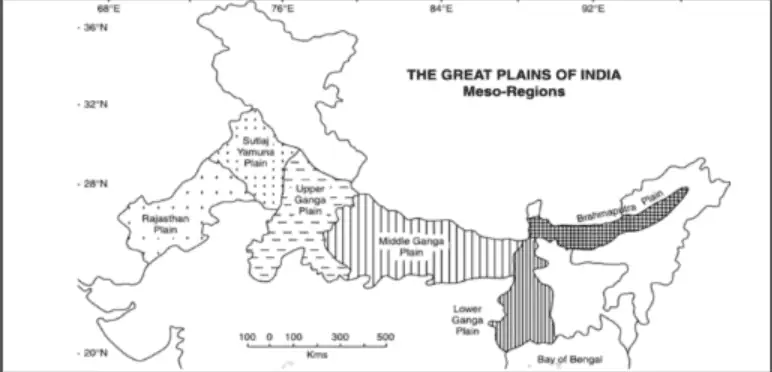
The expansive geographical expanse referred to as the Great Plains of India encompasses the verdant and fertile lowlands stretching between the Indus and Ganges rivers. These sprawling lands are commonly recognized as the Indo-Gangetic plains, owing to their historical and geographical significance.
Encompassing a vast area of northern India, these plains are a testament to the country’s agricultural richness and historical importance. Stretching from the northwestern Indus River to the northeastern Ganges River, this region plays a pivotal role in shaping India’s culture, economy, and civilization.
The Indo-Gangetic plains are renowned for their exceptionally fertile soil, which has supported agriculture for millennia. The annual monsoon rains replenish the land with vital nutrients, making it one of the world’s most productive agricultural regions. This fertility has allowed the plains to sustain a large population and contribute significantly to India’s food production.
Furthermore, the plains have played a pivotal role in the country’s history and culture. They have been home to several ancient civilizations, including the Indus Valley Civilization, which flourished along the banks of the Indus River over 4,000 years ago. The fertile lands of these plains have attracted settlers, conquerors, and traders for centuries, leading to the exchange of ideas, languages, and cultures.
Today, the Indo-Gangetic plains remain the heartland of India, with major cities like Delhi, Kolkata, and Lahore situated within their borders. They continue to be a vital source of agricultural output, supplying not only India but also neighboring regions with grains, rice, sugarcane, and cotton. Additionally, these plains are central to India’s transportation network, making them a hub for trade and commerce.
The Great Plains of India, also known as the Indo-Gangetic plains, are a vast and fertile region that has played a pivotal role in the history, culture, and economy of India. Their lush landscapes, fertile soil, and historical significance continue to shape the nation’s identity and prosperity.
READ MOREHow To Prepare For APSC Exam: Indo-Gangetic Plains ( Important for APSC)Indo-Gangetic Plains:
The Indo-Gangetic Plains are geographically distinguished by the 300-meter contour line, which acts as the dividing line between the Himalayas and the Gangetic Basin. To the south, their boundary aligns with the edge of the Indian peninsula, following the 75-meter contours for most of its extent and dipping to 35 meters in the northeastern portion, nearer to the delta region.
These plains exhibit remarkable flatness, characterized by a gentle slope that ranges from approximately 1:1000 to 1:2000. Their terrain is predominantly uniform and rolling, maintaining a consistent and unvarying topographical profile throughout.

Formation of the Indo-Gangetic-Brahmaputra Plain
- The genesis of the Indo-Gangetic plain is closely intertwined with the formation of the Himalayas.
- Initially, rivers flowed into the Tethys Sea before the collision of the Indian Plate with the Eurasian Plate, driven by continental drift and plate tectonics.
- These rivers deposited substantial sediment in the Tethys Geosyncline.
- Over time, these sediments were uplifted, folded, and compressed due to the northward movement of the Indian Plate.
- Simultaneously, this movement created a trough south of the rising Himalayas.
- The intricate geological processes led to the gradual formation of the Indo-Gangetic-Brahmaputra Plain, a vast and fertile lowland region in northern India, shaped by this geological history.

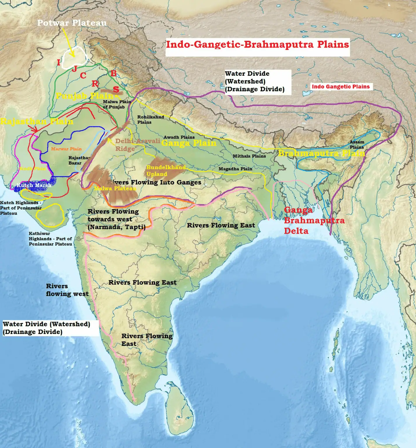
The Indo-Gangetic-Brahmaputra Plain’s regional divisions
- Plain of Sindh.
- Rajasthan Plain.
- Punjab Plain.
- Ganga Plain.
- The Brahmaputra Plain.
- Brahmaputra-Ganga Delta
Sindh Plain in Pakistan:
- Sindh Plain in Pakistan is primarily composed of Bhangar Plains, forming its fundamental geological composition.
- Within this region, dhors, which are long and narrow depressions, are still evident, serving as traces of past river courses.
- Some of these dhors within the Sindh Plain also contain alkaline lakes, contributing to the diverse and unique landscape of the area.
Rajasthan Plain:
- Predominantly occupied by the Thar Desert, also known as the Great Indian Desert, which characterizes its arid landscape.
- Beneath the desert facade, a few outcrops of gneisses, schist, and granite hint at its connection to the Peninsular Plateau. Despite its desert appearance, it conceals its true geological identity.
- The Rajasthan Plain exhibits a undulating terrain, creating pockets of fertility that support agriculture in certain areas. It is crisscrossed by several short seasonal streams originating from the Aravali Range.
- A notable seasonal stream, the Luni, eventually flows into the Rann of Kutch. To the north of the Luni lies the Thali, a sandy plain region.
- The Marwar Plain, a significant portion of the Rajasthan Plain, is synonymous with the arid expanse known as Marusthali. Its western sector is characterized by shifting sand dunes.
- The Khejri tree, associated with the Bishnoi tribe, stands as the solitary vegetation in the Marusthali, where annual rainfall averages around 25 cm.
- Dhrian, characterized by transient sand dunes, can be found within the Marusthali region.
- The semi-arid fertile plains or green patches of the Rajasthan Plain are referred to as ROHI.
- Located in the eastern Thar Desert, Rajasthan Bagar is a semi-arid plain that extends up to the Aravali Range.
Punjab Plain:
- The Punjab Plain owes its formation to the convergence of the five major rivers of the Indus River System.
- This plain is predominantly characterized by the “doabs,” the fertile land areas between two rivers.
- The deposition of sediments along these rivers has linked the doabs, creating a uniform landscape.
- Often referred to as “The Land of Five Waters,” Punjab derives its name from the Jhelum, Chenab, Ravi, Sutlej, and Beas rivers. However, these rivers exhibit poor drainage and are susceptible to flooding.
- The eastern boundary of the Punjab Haryana plain is defined by the subsurface Delhi-Aravali ridge.
- The northern part of this plain has suffered significant degradation due to the presence of numerous streams known as Chos, resulting in pronounced gullying.
- Within Haryana lies the region known as the “Haryana Tract,” situated between the Ghaggar and Yamuna rivers.
- This area acts as a natural water barrier, effectively separating the Sutlej and Yamuna rivers.
- The Ghaggar River, often considered the modern successor to the ancient Saraswati River, is the sole river flowing between the Yamuna and the Sutlej rivers.
Ganga Plain:
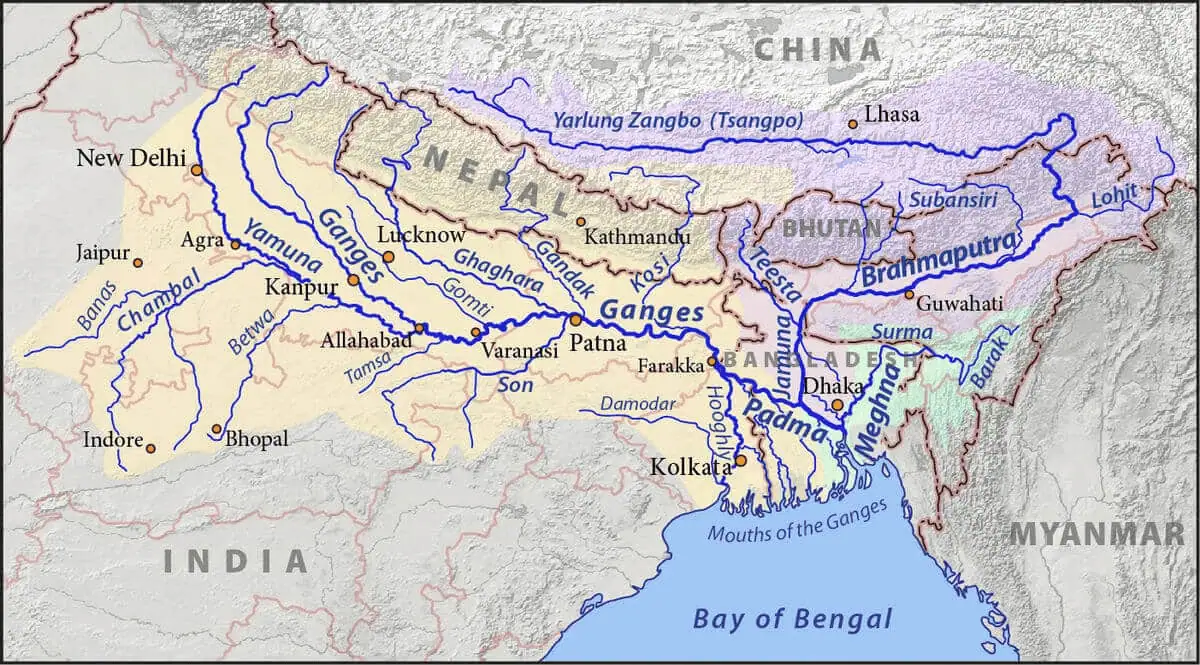
- The expansive Ganga Plain owes its formation to the relentless action of the Ganga River and its numerous tributaries, originating from the Himalayas, which transported substantial amounts of alluvial sediment from the mountains and deposited it across this vast expanse.
- The overall terrain of this plain gently slopes towards the east and southeast. Along the lower sections of the Ganges River, the landscape features distinct geographical features such as levees, bluffs, oxbow lakes, marshes, and ravines, reflecting the gradual flow of the river in these areas.
- The formation of the Ganga Plain was further influenced by peninsular rivers like the Chambal, Betwa, Ken, Son, and others, which joined the expansive Ganga river system, contributing to its fertile plains.
- It’s important to note that many of the rivers in this region exhibit a propensity to change their course over time, making the Ganga Plain susceptible to periodic floods. Among these, the Kosi River has earned the infamous moniker of the “Sorrow of Bihar” due to its historical flood-related devastations.
The Ganga-Brahmaputra Delta:
- This region boasts the distinction of hosting the world’s largest delta, characterized by its vast expanse and intricate water network.
- Within the delta region, the Ganga River bifurcates into multiple water channels, creating a complex network of estuaries, mud flats, mangrove swamps, sandbanks, islands, and forelands along the seaward face of the delta.
- A significant portion of the coastal delta is covered by tidal woodlands, earning them the name “Sunderbans” due to the dominance of the Sundri tree in this area.
The Brahmaputra Plain:
- This expansive region is often referred to as the Brahmaputra Valley, Assam Valley, or Assam Plain due to its predominant location within the state of Assam.
- The Brahmaputra Plain encompasses extensive areas of marshland, with Terai or semi-terai conditions emerging as a result of the formation of alluvial fans from coarse alluvial debris.
- This is an aggradational plain shaped by the continuous deposition of sediment by the Brahmaputra River and its various tributaries.
- The numerous tributaries originating from the north create a multitude of alluvial fans, leading to the branching of these tributaries into multiple channels. This complex network of channels results in the river’s meandering pattern and the formation of bill and oxbow lakes.
- Its western boundary is defined by the Indo-Bangladesh border and the border of Bangladesh, while the eastern boundary is marked by the Purvanchal hills.

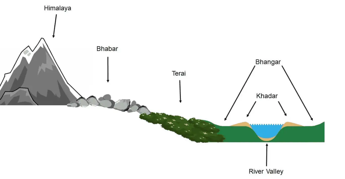
Longitudinal Profile – Indo Gangetic Plains
- Bhabhar
- Tarai
- Bangar
- Khadar

The Bhabhar Region:
- Situated adjacent to the Shiwalik foothills, this region is characterized by the presence of coarser materials such as cobbles, pebbles, gravels, and boulders, along with coarse sand.
- It constitutes a narrow, porous belt at the northernmost edge of the Indo-Gangetic plain, spanning approximately 8-16 kilometers in width and extending in an east-west direction along the foothills, forming what are known as alluvial fans of the Shiwaliks.
- Remarkably, the Bhabhar Region exhibits a remarkable continuity from the Indus River in the west to the Tista River in the east.
- Rivers descending from the Himalayas deposit their sedimentary load along the foothills in the form of these alluvial fans, which eventually coalesce to create the Bhabhar belt.
- The most distinctive feature of the Bhabhar Region is its high porosity, attributed to the accumulation of numerous pebbles and rock debris across the alluvial fans. This porosity leads to the peculiar phenomenon where streams disappear upon entering the Bhabhar region, except during the rainy season.
- The Bhabhar belt is relatively narrower in the eastern part and expands in the western and north-western hilly regions.
- Extending from Punjab to Assam Himalayas, the Bhabhar zone covers a substantial geographical range.
- The region has a complex topographical profile with a general slope of approximately 1:6000.
- Due to its challenging terrain, the Bhabhar Region is not suitable for agriculture, and it primarily supports the growth of large trees with robust root systems.
Terai Plains:
- Adjacent to the Bhabhar zone, the Terai Plains exhibit marshy characteristics, particularly in proximity to the Bhabhar region. These plains are exceptionally flat and densely forested, running parallel to the mountains from Punjab to Assam.
- The Terai is a narrow tract located to the south of the Bhabhar region and shares a parallel alignment with it. It is typically ill-drained, damp (marshy), and characterized by dense forests.
- The width of the Terai ranges from approximately 15 to 30 kilometers, with its widest stretch found in Bihar and eastern Uttar Pradesh and its narrowest in the eastern part of the region.
- Underground streams from the Bhabhar belt resurface in the Terai, contributing to its marshy nature.
- The eastern part of the Terai is more prominent than its western counterpart, primarily due to the relatively higher amount of rainfall received in the eastern regions.
- Much of the Terai land, especially in Punjab, Uttar Pradesh, and Uttarakhand, has been converted into agricultural land, yielding favorable crops like sugarcane, rice, and wheat.
- Terai soils are notable for their richness in nitrogen and humus content.
- While agriculture has transformed a significant portion of the Terai, it is essential to acknowledge that deforestation has been a common practice in this region to make way for agricultural activities.
Bangar Region:
- The Bangar Region extends across the entire Gangetic plain, encompassing a significant portion of this fertile landscape.
- Bangar consists of older alluvial deposits found along the riverbeds, creating terraces elevated above the floodplain.
- These terraces often contain calcareous concretions known as ‘KANKAR,’ which are characteristic of this region.
- Variations of Bangar include ‘The Barind plains’ in the deltaic region of Bengal and the ‘bhur formations’ in the middle Ganga and Yamuna doab. Bhur refers to elevated land along the banks of the Ganga River, especially in the upper Ganga-Yamuna Doab. This formation results from the accumulation of wind-blown sands during the hot, dry months of the year.
- Fossils of various animals such as rhinoceros, hippopotamus, and elephants have been discovered within the Bangar region, providing insights into its prehistoric ecology.
- One distinctive feature of Bangar is the presence of Kankar deposits, which consist of fragments of limestone and serve as natural supplements of bases to the soil.
- Unfortunately, in several parts of Uttar Pradesh, where Bangar is known as Usar, it has suffered serious degradation, resulting in infertility due to salinization, although such areas are relatively limited.
Barind Tract (Barind Plains)
- The Barind Tract, alternatively known as the Varendra Tract in English and Borendro Bhumi in Bengali, represents the largest physiographic unit in the Bengal Basin dating back to the Pleistocene era.
- Geographically, the Barind Tract encompasses parts of northwestern Bangladesh and north-central West Bengal state in India.
- Situated to the northwest of the confluence of the upper Padma (Ganga) and Jamuna (the Brahmaputra in Bangladesh) rivers, it is bordered by the floodplains of the Mahananda River to the west and the Karatoya River to the east. Both the Mahananda and Karatoya are tributaries of the upper Padma and Jamuna rivers, respectively.
- The Barind Tract is characterized by undulating terrain with reddish and yellowish clay soils.
- This region has long been recognized as a unit featuring old alluvial deposits, contributing to its distinctive geological and geographical characteristics.
Khadar Region:
- The Khadar Region comprises newer alluvial deposits and constitutes the floodplains adjacent to the riverbanks.
- These floodplains receive fresh layers of alluvium through river floods nearly every year.
- As a result of this consistent replenishment of alluvium, the Khadar soils are renowned as the most fertile among the Ganges’ soil types.
Reh or Kollar:
- Reh or Kollar refers to the accumulation of saline efflorescences in arid regions of Haryana.
- These Reh areas have expanded in recent years, primarily due to increased irrigation practices, which facilitate the upward movement of salts through capillary action to the soil surface.
Significance of the Plain:
- This quarter of the country’s landmass is home to half of India’s population, showcasing its immense demographic importance.
- The presence of fertile alluvial soils, flat terrain, perennial slow-moving rivers, and a favorable climate creates an environment conducive to intensive agricultural activities.
- Extensive irrigation practices have transformed Punjab, Haryana, and the western part of Uttar Pradesh into the granary of India, often likened to the world’s prairies.
- A well-developed network of roads and railways spans across the entire plain, excluding the Thar Desert. This infrastructure has catalyzed large-scale industrialization and urbanization in the region.
- The plain also holds significant cultural value, attracting cultural tourism due to the presence of numerous religious sites along the banks of sacred rivers such as the Ganga and the Yamuna, which hold deep significance for Hindus. Additionally, this region witnessed the flourishing of religions like Buddhism and Jainism, as well as the emergence of Bhakti and Sufism movements.
1. What are the Indo-Gangetic Plains?
The Indo-Gangetic Plains, also known as the Great Plains of India, are a vast and fertile region in South Asia, extending from the Indus River in the west to the Brahmaputra River in the east, between the Himalayan foothills and the peninsular plateau.
2. What is the significance of the Indo-Gangetic Plains?
These plains are of immense agricultural importance and host a significant portion of India’s population. They are often referred to as the “breadbasket” of India due to their high agricultural productivity.
3. What are the main geographical features of the Indo-Gangetic Plains?
The region is characterized by flat terrain, fertile alluvial soil, slow-flowing rivers, and a network of canals for irrigation.
4. What are the major rivers that flow through the Indo-Gangetic Plains?
The Indo-Gangetic Plains are traversed by several major rivers, including the Ganges, Yamuna, Brahmaputra, Indus, and their tributaries.
5. How do the plains benefit agriculture?
The fertile alluvial soil and the availability of water from the rivers make the Indo-Gangetic Plains highly conducive to agriculture. They support the cultivation of various crops, including rice, wheat, sugarcane, and cotton.