The Plate Tectonic Theory stands as a foundational concept within the realm of geology, elucidating the intricate dynamics governing Earth’s crustal plates, their movement, and creation. The origins of this theory trace back to Alfred Wegener, a German meteorologist, who initially presented it in terms of continental drift. Since then, Plate Tectonic Theory has gained wide scientific acceptance, positing that the Earth’s lithosphere, a rigid outer shell, comprises several major tectonic plates, which have been in motion for approximately 3.4 billion years.
Comprising seven or eight major plates, this lithospheric mosaic further subdivides into smaller entities referred to as ‘platelets.’ The profound impact of Plate Tectonic Theory extends to reshaping our understanding of Earth’s geological history. It has provided valuable insights into the processes behind the formation of mountains, earthquakes, volcanoes, and various other geological phenomena.

Definition of plate tectonic
Plate Tectonics Theory stands as a consistent framework for understanding a wide range of geological phenomena, including mountain formation, volcanic eruptions, earthquakes, the evolution of Earth’s surface, and the reconstruction of past continents and oceans. This theory delves into the dynamics of the planet’s outer shell, known as the lithosphere. The concept of tectonic plates was first introduced in 1967, marking a pivotal moment in Earth sciences. The advent of this theory has ushered in a profound revolution in our understanding of the Earth’s geological processes.
Plate tectonic theory
In the context of plate tectonics, the Earth’s mantle, which is the solid inner layer just above the core, is overlaid by a series of plates that traverse the planet’s outer shell. These plates, in contrast to the mantle beneath them, exhibit characteristics akin to rigid, unyielding shells. This outermost, robust layer is referred to as the lithosphere.
Tectonic plates can be categorized as either continental or oceanic based on their predominant location. For instance, the Eurasian plate is predominantly continental, while the Pacific plate is primarily oceanic in nature.

Plate tectonics movements
Tectonic plates exhibit continuous horizontal movement over the Asthenosphere, behaving like solid entities, yet they are far from immobile. Interactions such as plate collisions, separations, and close encounters can lead to the occurrence of earthquakes and volcanic eruptions.
In terms of their movement rates, tectonic plates exhibit a broad spectrum of speeds. For example, the East Pacific Rise, located in the South Pacific approximately 3,400 km west of Chile, experiences the fastest movement, exceeding 15 cm per year, while the Arctic Ridge undergoes the slowest movement, at less than 2.5 cm per year.
Beneath these rigid plates lies a layer of malleable rock believed to undergo circular motion. This dynamic substance ascends, surfaces, spreads, cools, and subsequently descends to greater depths. The driving force behind plate movement is attributed to this gradual motion of the heated, softened mantle underlying these unyielding plates.
Fundamentals of Plate tectonic theory
- Plate Tectonic Theory is a cornerstone in geology and Earth sciences, remarkably simple in its essence.
- Earth’s surface layer has a thickness ranging from 50 to 100 km (equivalent to 30 to 60 miles). These sections combine to form what we call the lithosphere.
- The term “Lithosphere” has its roots in Greek, where “lithos” means “rocks,” emphasizing its composition.
- Beneath the lithosphere, there’s a partially molten layer called the asthenosphere. “Asthenos” in Greek means “weak,” and this is where the lithosphere gently slides over, acting like a detached boundary.
- Tectonic plates within the lithosphere are in constant motion on the Earth’s surface. They engage in various interactions such as collision, separation, and convergence with neighboring plates.
- The exact forces responsible for propelling these plates are still not completely understood. Two leading theories suggest either convection currents in the Earth’s mantle or gravitational forces associated with heavy crustal materials might be at play.
- The collisions of these tectonic plates give rise to a range of geological hazards, including earthquakes and volcanic eruptions.
In summary, Plate Tectonic Theory, although elegantly simple, elucidates the division and movement of Earth’s surface into plates, which subsequently lead to various geological phenomena and hazards. The driving mechanisms behind plate motion continue to be a topic of scientific inquiry.
The Major and Minor Plates
| Major plates | Minor Plates |
| Antarctic Plate | Cocos Plate: Between Central America and Pacific Plate |
| Pacific Plate | Nazca Plate: Between South America and Pacific Plate |
| India-Australia-New Zealand Plate | Philippine Plate: Between the Asiatic and Pacific Plate |
| Africa with the Eastern Atlantic Floor Plate | Caroline Plate: Between the Philippine and Indian Plate |
| Eurasia and the Adjacent Oceanic Plate | Fuji Plate: North-east of Australia |
| North American Plate | Juan De Fuca Plate: South-East of North American Plate |
| South American Plate | Arabian Plate: Mostly the Saudi Arabian landmass |
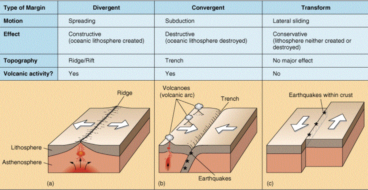
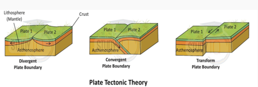
Three types of motion are possible between the plates:
- Separation or divergent or constructive plate margins
- Closing together or convergent or destructive plate margins
- Transform or conservative plate margin
Convergent Boundaries
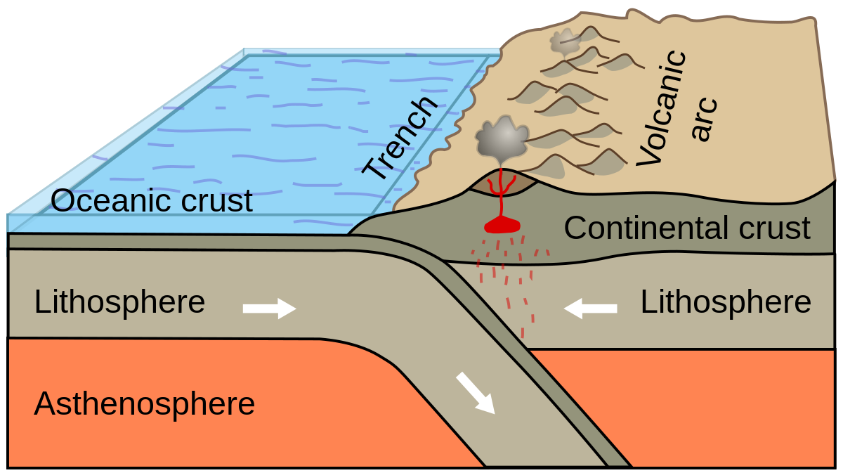
Convergent plate boundaries are geological regions where tectonic plates collide, often referred to as “destructive borders.” These collisions give rise to significant geological features and phenomena.
One common occurrence at convergent boundaries is the formation of subduction zones. In these zones, a denser tectonic plate, typically an oceanic plate, sinks beneath a lighter plate, which can be either oceanic or continental. As the denser plate descends into the Earth’s mantle, it undergoes transformation, generating buoyant magma that rises through the crust. Over time, this process leads to the creation of deep ocean trenches.
Another notable result of convergent boundaries is the development of volcanic arcs. As the magma from the subducting plate rises, it often forms a chain of active volcanoes. These volcanic arcs can stretch over significant distances and are a defining feature of convergent plate boundaries.
Convergent boundaries also play a key role in the formation of mountain ranges and island arcs. When plates collide and compress against each other, land is uplifted, leading to the creation of towering mountain ranges. An excellent example is the Himalayan Mountain Range, which formed as a result of the ongoing collision between the Indian and Eurasian plates.
Convergent plate boundaries can occur in three primary ways: between an oceanic and continental plate, between two oceanic plates, or between two continental plates. Each type of convergence results in distinct geological features and processes.
For instance, in oceanic-continental convergence, the denser oceanic plate is forced beneath the continental plate. An example is the Washington–Oregon coastline in the United States, where the Juan de Fuca oceanic plate subducts beneath the North American continental plate.
In oceanic-oceanic convergence, one oceanic plate descends beneath another. The Mariana Trench, the deepest part of the Earth, is a prime example, where the smaller Philippine plate subducts beneath the powerful Pacific plate.
When two continental plates collide, it can lead to the formation of massive mountain ranges. The Himalayas, the world’s highest mountain range, is the result of the ongoing collision between the Indian and Eurasian plates.
Convergent plate boundaries are dynamic regions where tectonic plates collide, resulting in a wide array of geological features and processes that continuously shape the Earth’s surface.
Divergent Boundaries
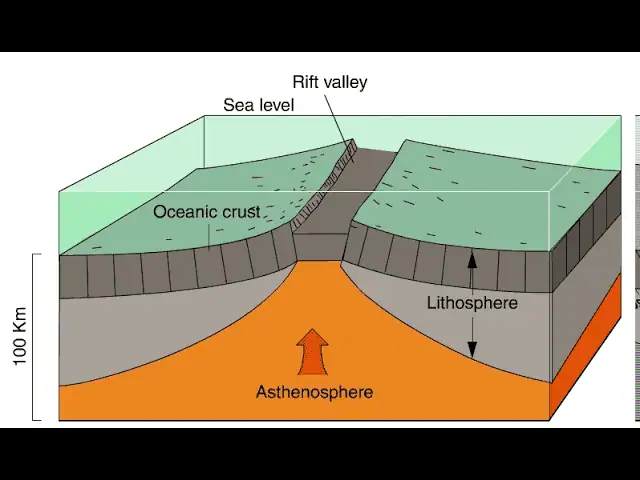
Divergent boundaries are geological phenomena that occur when tectonic plates move away from each other. These boundaries are often referred to as “productive boundaries” due to the significant geological activity associated with them. At divergent boundaries, several key features and processes can be observed, including rift valleys and seafloor spreading.
One of the central mechanisms at divergent boundaries involves the upwelling of magma from the Earth’s mantle, which rises closer to the surface along these boundaries. This rising magma exerts pressure on one or more tectonic plates, causing them to move apart. Along the resulting seam or fissure, mountains and volcanoes may form as a result of the volcanic activity induced by the separation of the plates. Additionally, the stretching and pulling apart of the Earth’s crust during this process lead to the expansion of vast basins, contributing to the renewal and formation of oceanic crust on the seafloor.
One of the most well-known examples of a divergent boundary is the Mid-Atlantic Ridge, which runs through the Atlantic Ocean and separates the American Plate from the Eurasian and African Plates. This extensive underwater mountain range stretches for approximately 10,000 miles, making it the world’s largest mountain system.
Notably, when tectonic plates separate at divergent boundaries on land, they can create prominent features such as rift valleys. For instance, the Great Rift Valley in Africa is a striking example of a rift valley formed by the stretching and pulling apart of tectonic plates. Over millions of years, if the divergence of plates in this region continues, it could ultimately lead to the eastern part of Africa breaking away from the continent to form a new landmass. This separation would be marked by the presence of a mid-ocean ridge, similar to those found beneath the oceans.
Transform Boundaries
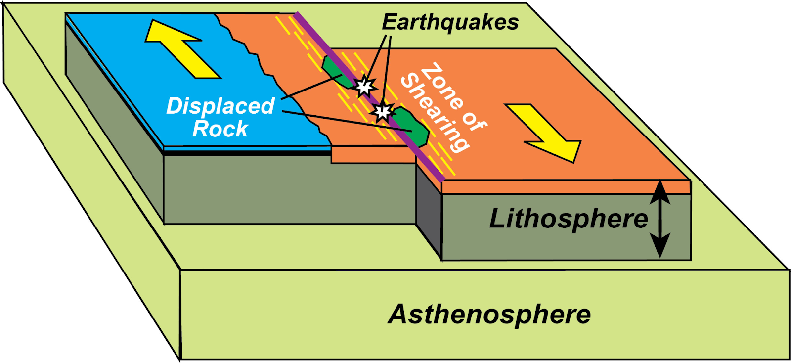
Transform boundaries form when tectonic plates move horizontally alongside each other. However, in some cases, these plates can get stuck at their contact points. Unlike other types of plate interactions, transform boundaries are considered conservative because they neither create nor destroy crustal material. Consequently, they do not give rise to visually striking geological features such as mountains or oceans. Nonetheless, the static friction at these boundary zones often leads to the accumulation of stress, which can eventually result in significant earthquakes. These sudden seismic events occur when the accumulated stress causes rocks to crack or slip, causing a rapid release of energy. The zones where this slippage or breakage occurs are known as faults.
A significant concentration of Earth’s faults is found in the Ring of Fire, which encircles the Pacific Ocean along transform boundaries. A well-known example of a transform boundary is the San Andreas Fault in California, where the Pacific Plate moves northward alongside the North American Plate. This fault is one of the most active and renowned in the Ring of Fire region, having been responsible for the devastating earthquake that struck San Francisco in 1906.
Importance of plate tectonic
The importance of Plate Tectonics is profound and encompasses several key aspects:
- Plate tectonics play a fundamental role in shaping nearly all major landforms on Earth. This includes the creation of mountains, valleys, and ocean basins through processes like subduction, collision, and rifting.
- Magmatic eruptions associated with plate tectonics bring forth new minerals from the Earth’s core. These eruptions contribute to the formation of various mineral deposits, some of which are economically valuable. Notably, minerals like copper and uranium are often found in proximity to plate boundaries.
- The presence of valuable minerals near plate boundaries has significant economic implications. Mining and resource extraction activities are often concentrated in regions influenced by plate tectonics due to the high concentrations of economically valuable materials.
- Our current understanding of crustal plate movements enables us to make informed predictions about the future configuration of landmasses. For instance, if current trends persist, we can anticipate the eventual separation of North and South America, the detachment of a landmass from the eastern coast of Africa, and the gradual movement of Australia closer to Asia.
In summary, Plate Tectonics not only shapes our planet’s physical features but also has far-reaching effects on mineral resources and the future geography of Earth.
Comparison: Continental Drift & See Floor Spreading & Plate Tectonics
| Aspect | Continental Drift | Sea Floor Spreading | Plate Tectonics |
| Explained by | Alfred Wegener in the 1920s | Arthur Holmes (Convectional Current Theory, 1930s) and Harry Hess (Sea Floor Spreading, 1940s) | McKenzie and Parker (1967) with further development by Morgan (1968) |
| Theory | Explains the Movement of Continents only | Explains the Movement of Oceanic Plates only | Explains the Movement of Lithospheric plates that include both continents and oceans |
| Forces for movement | Buoyancy, gravity, pole-fleeing force, tidal currents, tides, | Convection currents in the mantle drag crustal plates | Convection currents in the mantle drag crustal plates |
| Evidence | Apparent affinity of physical features, botanical evidence, fossil evidence, Tillite deposits, placer deposits, rocks of the same age across different continents, etc. | Ocean bottom relief, Paleomagnetic rocks, distribution of earthquakes and volcanoes, etc. | Ocean bottom relief, Paleomagnetic rocks, distribution of earthquakes and volcanoes, gravitational anomalies at trenches, etc. |
| Drawbacks | Too general with silly and sometimes illogical evidence. | Doesn’t explain the movement of continental plates | ——————— |
| Acceptance | Discarded | Not complete | Most widely accepted |
| Usefulness | Helped in the evolution of convection current theory and seafloor spreading theory | Helped in the evolution of plate tectonics theory | Helped us understand various geographical features |
Plate Tectonics Diagram
1. What is Plate Tectonic Theory?
- Plate tectonic theory is a scientific concept that explains the movement and interaction of Earth’s lithospheric plates, which make up the Earth’s outer shell. It describes how these plates move, interact, and shape the Earth’s surface.
2.What Causes the Movement of Tectonic Plates?
The movement of tectonic plates is primarily driven by convection currents in the Earth’s mantle. As material in the mantle heats up, it becomes less dense and rises, while cooler, denser material sinks. This convective motion causes the plates to move.
3. What Are the Three Types of Plate Boundaries?
There are three main types of plate boundaries: divergent boundaries (where plates move apart), convergent boundaries (where plates move toward each other), and transform boundaries (where plates slide past each other horizontally).
4. What Geological Features Are Associated with Plate Tectonics?
- Plate tectonics are responsible for various geological features, including mountain ranges, ocean basins, volcanoes, earthquakes, and rift valleys. These features result from the interactions and movements of tectonic plates.
5. What Evidence Supports Plate Tectonic Theory?
- Evidence for plate tectonics includes the distribution of earthquakes and volcanoes, the pattern of magnetic striping on the ocean floor, the alignment of mountain ranges, and the matching of fossil and rock formations across continents.
Also Read- Climate Of India (Important Notes For APSC)